File:MPP stereo analysis.jpg
Jump to navigation
Jump to search
No higher resolution available.
MPP_stereo_analysis.jpg (512 × 512 pixels, file size: 40 KB, MIME type: image/jpeg)
Captions
Captions
Add a one-line explanation of what this file represents
Summary[edit]
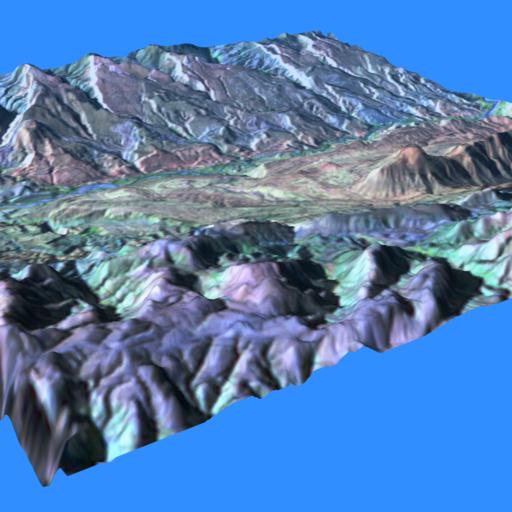
| Description | Computer rendering of a topographic map of the Camargo Syncline in Bolivia. The topographic data was generated by a stereo analysis algorithm developed by Jim Strong (NASA/GSFC) for the Goodyear MPP (Massively Parallel Processor). |
| Date | circa 1991 |
| Source | Own work |
| Author | Dave Pape (while NASA employee) |
| Permission (Reusing this file) |
PD |
Licensing[edit]
| This file is in the public domain in the United States because it was solely created by NASA. NASA copyright policy states that "NASA material is not protected by copyright unless noted". (See Template:PD-USGov, NASA copyright policy page or JPL Image Use Policy.) | ||
 |
Warnings:
|
File history
Click on a date/time to view the file as it appeared at that time.
| Date/Time | Thumbnail | Dimensions | User | Comment | |
|---|---|---|---|---|---|
| current | 14:57, 24 January 2007 | | 512 × 512 (40 KB) | Davepape (talk | contribs) | {{Information |Description=Computer rendering of a topographic map of the Camargo Syncline in Bolivia. The topographic data was generated by a stereo analysis algorithm developed by Jim Strong (NASA/GSFC) for the {{w|Goodyear MPP}} (Massively Parallel Pro |
You cannot overwrite this file.
File usage on Commons
The following page uses this file:
File usage on other wikis
The following other wikis use this file:
- Usage on en.wikipedia.org
- Usage on it.wikipedia.org
- Usage on www.wikidata.org