File:MIA - Miami International Airport FAA diagram.svg
Jump to navigation
Jump to search

Size of this PNG preview of this SVG file: 512 × 352 pixels. Other resolutions: 320 × 220 pixels | 640 × 440 pixels | 1,024 × 704 pixels | 1,280 × 880 pixels | 2,560 × 1,760 pixels.
Original file (SVG file, nominally 512 × 352 pixels, file size: 544 KB)
Captions
Captions
Add a one-line explanation of what this file represents
Summary[edit]
| Description |
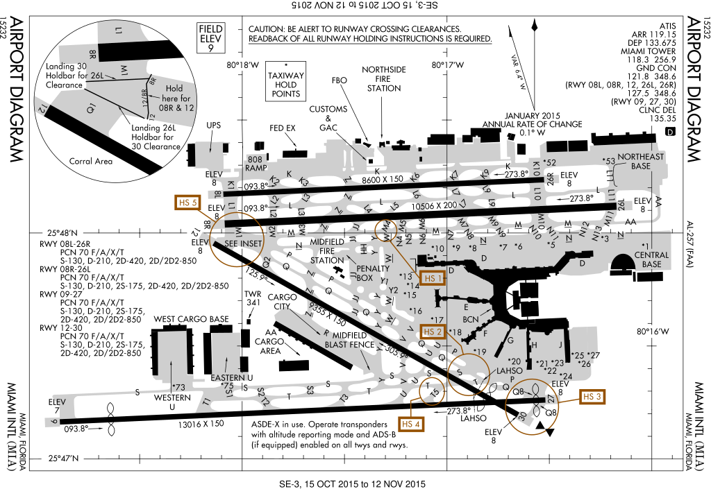
English: Made from a combination of File:MIA - Miami International Airport FAA diagram.png and http://www.naco.faa.gov/d-tpp/0910/00257AD.PDF. The PNG was out of date, so a lot of the data came from the PDF. Please note that the PDF is only good for one month. After that, neither it nor this SVG should be used for navigation. |
| Date | |
| Source | Own work |
| Author | Will Pittenger |
This W3C-unspecified vector image was created with Inkscape .
| Camera location | | View this and other nearby images on: OpenStreetMap |
|---|
Licensing[edit]
I, the copyright holder of this work, hereby publish it under the following license:
This file is licensed under the Creative Commons Attribution-Share Alike 3.0 Unported license.
- You are free:
- to share – to copy, distribute and transmit the work
- to remix – to adapt the work
- Under the following conditions:
- attribution – You must give appropriate credit, provide a link to the license, and indicate if changes were made. You may do so in any reasonable manner, but not in any way that suggests the licensor endorses you or your use.
- share alike – If you remix, transform, or build upon the material, you must distribute your contributions under the same or compatible license as the original.
File history
Click on a date/time to view the file as it appeared at that time.
| Date/Time | Thumbnail | Dimensions | User | Comment | |
|---|---|---|---|---|---|
| current | 13:58, 27 October 2015 | | 512 × 352 (544 KB) | Kopiersperre (talk | contribs) | new version |
| 08:16, 2 November 2009 |  | 2,283 × 1,543 (326 KB) | Will Pittenger (talk | contribs) | Adjusted filter settings for objects that hide the grid in order to make text readable | |
| 08:07, 2 November 2009 |  | 2,283 × 1,543 (326 KB) | Will Pittenger (talk | contribs) | It looks like the file didn't get saved prior to upload. So Commons got an out of date version. | |
| 08:02, 2 November 2009 |  | 2,283 × 1,543 (324 KB) | Will Pittenger (talk | contribs) | {{Information |Description={{en|1=Made from a combination of File:MIA - Miami International Airport FAA diagram.png and [http://www.naco.faa.gov/d-tpp/0910/00257AD.PDF http://www.naco.faa.gov/d-tpp/0910/00257AD.PDF]. The PNG was out of date, so a lo |
You cannot overwrite this file.
File usage on Commons
The following 3 pages use this file:
File usage on other wikis
The following other wikis use this file:
- Usage on ar.wikipedia.org
- Usage on de.wikipedia.org
- Usage on en.wikipedia.org
- Usage on fr.wikipedia.org
- Usage on he.wikipedia.org
- Usage on id.wikipedia.org
- Usage on ja.wikipedia.org
- Usage on no.wikipedia.org
- Usage on pl.wikipedia.org
- Usage on simple.wikipedia.org
- Usage on ta.wikipedia.org
- Usage on th.wikipedia.org