File:Městské části Brna.PNG
Jump to navigation
Jump to search

Size of this preview: 634 × 599 pixels. Other resolutions: 254 × 240 pixels | 508 × 480 pixels | 891 × 842 pixels.
Original file (891 × 842 pixels, file size: 73 KB, MIME type: image/png)
Captions
Captions
Add a one-line explanation of what this file represents

|
This locator map image could be re-created using vector graphics as an SVG file. This has several advantages; see Commons:Media for cleanup for more information. If an SVG form of this image is available, please upload it and afterwards replace this template with
{{vector version available|new image name}}.
It is recommended to name the SVG file “Městské části Brna.svg”—then the template Vector version available (or Vva) does not need the new image name parameter. |
Summary[edit]
| Description |
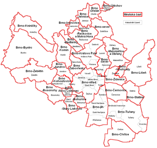
English: Map of municipal districts and cadastral areas of Brno Čeština: Mapka městských částí a katastrálních území Brna |
| Date | 7. 12. 2010 |
| Source | Own work |
| Author | Mapového náložník |
| Other versions | Derivative works of this file: Městské části Brna a jejich znaky.png |
Licensing[edit]
| I, the copyright holder of this work, release this work into the public domain. This applies worldwide. In some countries this may not be legally possible; if so: I grant anyone the right to use this work for any purpose, without any conditions, unless such conditions are required by law. |
File history
Click on a date/time to view the file as it appeared at that time.
| Date/Time | Thumbnail | Dimensions | User | Comment | |
|---|---|---|---|---|---|
| current | 17:39, 7 December 2010 | | 891 × 842 (73 KB) | Mapového náložník (talk | contribs) | {{Information |Description={{en|1=Map of city quarters and cadastral areas of Brno}} {{cs|1=Mapka městských částí a katastrálních území statutárního města Brna}} |Source={{own}} |Author=Mapového náložník |Dat |
You cannot overwrite this file.
File usage on Commons
The following 2 pages use this file:
File usage on other wikis
The following other wikis use this file:
- Usage on cs.wikipedia.org
- Usage on en.wikipedia.org
- Usage on pl.wikipedia.org
- Usage on www.wikidata.org