File:München–Simbach.png
Jump to navigation
Jump to search

Size of this preview: 800 × 313 pixels. Other resolutions: 320 × 125 pixels | 640 × 250 pixels | 1,024 × 400 pixels | 2,323 × 908 pixels.
Original file (2,323 × 908 pixels, file size: 466 KB, MIME type: image/png)
Captions
Captions
Add a one-line explanation of what this file represents
Summary[edit]
| Description |
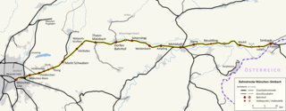
Deutsch: Karte der Bahnstrecke München–Simbach. Gezeichnet nach:
|
|||
| Date | ||||
| Source |
Map data by Openstreetmap
|
|||
| Author | Flummi-2011, OpenStreetMap contributors |
Licensing[edit]
This file is licensed under the Creative Commons Attribution-Share Alike 4.0 International license.
- You are free:
- to share – to copy, distribute and transmit the work
- to remix – to adapt the work
- Under the following conditions:
- attribution – You must give appropriate credit, provide a link to the license, and indicate if changes were made. You may do so in any reasonable manner, but not in any way that suggests the licensor endorses you or your use.
- share alike – If you remix, transform, or build upon the material, you must distribute your contributions under the same or compatible license as the original.
File history
Click on a date/time to view the file as it appeared at that time.
| Date/Time | Thumbnail | Dimensions | User | Comment | |
|---|---|---|---|---|---|
| current | 18:41, 12 April 2023 | 2,323 × 908 (466 KB) | Flummi-2011 (talk | contribs) | Wasentegernbach als Bf | |
| 21:15, 26 December 2020 | 2,323 × 908 (461 KB) | Flummi-2011 (talk | contribs) | größere Schrift bei den Flussnamen | ||
| 19:12, 26 December 2020 | 2,323 × 908 (461 KB) | Flummi-2011 (talk | contribs) | Staatsgrenze ergänzt, größere Schrift | ||
| 22:49, 25 December 2020 | 2,323 × 908 (451 KB) | Flummi-2011 (talk | contribs) | Namen der Knotenpunkte mit größerer Schrift versehen | ||
| 23:36, 6 December 2020 | 2,323 × 908 (448 KB) | Flummi-2011 (talk | contribs) | Farboptimierung | ||
| 23:31, 6 December 2020 | 2,323 × 908 (448 KB) | Flummi-2011 (talk | contribs) | Zuschnitt | ||
| 23:28, 6 December 2020 | 2,344 × 908 (451 KB) | Flummi-2011 (talk | contribs) | Uploaded a work by Flummi-2011, OpenStreetMap contributors from Map data by Openstreetmap {{ODbL OpenStreetMap}} with UploadWizard |
You cannot overwrite this file.
File usage on Commons
The following 9 pages use this file:
- User:Chumwa/OgreBot/Public transport information/2020 December 1-10
- User:Chumwa/OgreBot/Public transport information/2020 December 21-31
- User:Chumwa/OgreBot/Public transport information/2023 April 11-20
- User:Chumwa/OgreBot/Transport Maps/2020 December 1-10
- User:Chumwa/OgreBot/Transport Maps/2020 December 21-31
- User:Chumwa/OgreBot/Transport Maps/2023 April 11-20
- User:Clic/Nahverkehr in Deutschland/2023 April 11-20
- User:Nordlicht8/Rail Germany/2023 April 11-20
- Category:Bahnstrecke München–Simbach
File usage on other wikis
The following other wikis use this file:
- Usage on de.wikipedia.org
- Usage on hu.wikipedia.org
- Usage on ja.wikipedia.org
- Usage on nl.wikipedia.org
- Usage on www.wikidata.org