File:Lower Moss Hall, Blackshaw Head - geograph.org.uk - 102092.jpg
Jump to navigation
Jump to search
No higher resolution available.
Lower_Moss_Hall,_Blackshaw_Head_-_geograph.org.uk_-_102092.jpg (640 × 460 pixels, file size: 124 KB, MIME type: image/jpeg)
Captions
Captions
Add a one-line explanation of what this file represents
Summary
[edit]
| Description |
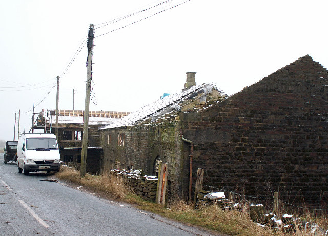
English: Lower Moss Hall, Blackshaw Head. Lower Moss Hall (Farm) is a grade 2 listed late 17th century house, forming a single range with the adjoining barn.
The house was occupied until about 2002. In 2003 unauthorised demolition and building work took place which included the stripping out of much of the interior, the replacement of the roof and the removal of the roof and part of the south wall of the barn. It has since received planning permission for renovation and a new 2 story extension which was well under construction at the time the photo was taken in January 2006. This style of laithe house is typical of the district. |
| Date | |
| Source | From geograph.org.uk |
| Author | Phil Champion |
| Attribution (required by the license) | Phil Champion / Lower Moss Hall, Blackshaw Head / |
| Object location | | View this and other nearby images on: OpenStreetMap |
|---|
_&language=en)
Licensing
[edit]

|
This image was taken from the Geograph project collection. See this photograph's page on the Geograph website for the photographer's contact details. The copyright on this image is owned by Phil Champion and is licensed for reuse under the Creative Commons Attribution-ShareAlike 2.0 license.
|
This file is licensed under the Creative Commons Attribution-Share Alike 2.0 Generic license.
Attribution: Phil Champion
- You are free:
- to share – to copy, distribute and transmit the work
- to remix – to adapt the work
- Under the following conditions:
- attribution – You must give appropriate credit, provide a link to the license, and indicate if changes were made. You may do so in any reasonable manner, but not in any way that suggests the licensor endorses you or your use.
- share alike – If you remix, transform, or build upon the material, you must distribute your contributions under the same or compatible license as the original.
File history
Click on a date/time to view the file as it appeared at that time.
| Date/Time | Thumbnail | Dimensions | User | Comment | |
|---|---|---|---|---|---|
| current | 00:13, 31 January 2010 | | 640 × 460 (124 KB) | GeographBot (talk | contribs) | == {{int:filedesc}} == {{Information |description={{en|1=Lower Moss Hall, Blackshaw Head. Lower Moss Hall (Farm) is a grade 2 listed late 17th century house, forming a single range with the adjoining barn. The house was occupied until about 2002. In 2 |
You cannot overwrite this file.
File usage on Commons
There are no pages that use this file.