File:Low Saxon Dialects.svg
Jump to navigation
Jump to search

Size of this PNG preview of this SVG file: 500 × 400 pixels. Other resolutions: 300 × 240 pixels | 600 × 480 pixels | 960 × 768 pixels | 1,280 × 1,024 pixels | 2,560 × 2,048 pixels.
Original file (SVG file, nominally 500 × 400 pixels, file size: 268 KB)
Captions
Captions
Add a one-line explanation of what this file represents
| Description |
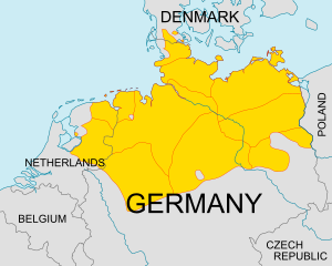
English: Map of Low Saxon dialects after 1945. Yellow: (from west to east)
Deutsch: Englische Karte der niederdeutschen Dialekte nach 1945. Gelb: (von West nach Ost)
Plattdüütsch: Koort vun de plattdüütschen Dialekten. Geel: (vun West na Oost)
|
| Date | (UTC) |
| Source | |
| Author |
|
This file is licensed under the Creative Commons Attribution-Share Alike 3.0 Unported license.
- You are free:
- to share – to copy, distribute and transmit the work
- to remix – to adapt the work
- Under the following conditions:
- attribution – You must give appropriate credit, provide a link to the license, and indicate if changes were made. You may do so in any reasonable manner, but not in any way that suggests the licensor endorses you or your use.
- share alike – If you remix, transform, or build upon the material, you must distribute your contributions under the same or compatible license as the original.
Original upload log[edit]
This image is a derivative work of the following images:
- File:Low_Saxon_dialects.png licensed with PD-user
- 2008-08-08T10:38:43Z Gruna 1 521x399 (10886 Bytes) See previous version
- 2008-04-04T14:47:26Z Slomox 521x399 (10860 Bytes)
- 2008-04-04T14:45:02Z Slomox 521x399 (10877 Bytes) removed Low Franconian, cause the name says 'Low Saxon'
- 2007-01-09T18:16:17Z Servien 521x399 (11380 Bytes) Map of Low Saxon dialects. Source: [[:en:Image:Low_Saxon_dialects.png]]
- File:Europe.svg licensed with PD-USGov-CIA-WF
Uploaded with derivativeFX
File history
Click on a date/time to view the file as it appeared at that time.
| Date/Time | Thumbnail | Dimensions | User | Comment | |
|---|---|---|---|---|---|
| current | 21:45, 6 February 2011 | | 500 × 400 (268 KB) | Alphathon (talk | contribs) | Minor fix to the Netherlands |
| 02:27, 6 February 2011 |  | 500 × 400 (267 KB) | Alphathon (talk | contribs) | Added some missing islands and fixed some minor errors | |
| 23:19, 5 February 2011 |  | 500 × 400 (264 KB) | Alphathon (talk | contribs) | Added additional place names and fixed clipping on Denmark. Rescaled Germany and Denmark labels | |
| 23:12, 5 February 2011 |  | 500 × 400 (250 KB) | Alphathon (talk | contribs) | Trimmed down (to something closer to the image on which it is based) | |
| 22:58, 5 February 2011 |  | 389 × 420 (260 KB) | Alphathon (talk | contribs) | Changed scale | |
| 22:52, 5 February 2011 |  | 194 × 210 (193 KB) | Alphathon (talk | contribs) | {{Information |Description={{en| Map of Low Saxon dialects. Yellow: (from west to east) * Dutch Low Saxon * Westphalian * Low Saxon * East Frisian * Eastphalian * Holsteinish * Schleswigish * Mecklenburgish * North Markish * South Markish }} {{de| Karte d |
You cannot overwrite this file.
File usage on Commons
The following page uses this file:
File usage on other wikis
The following other wikis use this file:
- Usage on ast.wikipedia.org
- Usage on bg.wikipedia.org
- Usage on cs.wikipedia.org
- Usage on en.wikipedia.org
- Usage on es.wikipedia.org
- Usage on fa.wikipedia.org
- Usage on gl.wikipedia.org
- Usage on he.wikipedia.org
- Usage on id.wikipedia.org
- Usage on kv.wikipedia.org
- Usage on lfn.wikipedia.org
- Usage on lv.wikipedia.org
- Usage on mk.wikipedia.org
- Usage on pa.wikipedia.org
- Usage on pnb.wikipedia.org
- Usage on sat.wikipedia.org
- Usage on simple.wikipedia.org
- Usage on sq.wikipedia.org
- Usage on sr.wikipedia.org
- Usage on th.wikipedia.org
- Usage on ur.wikipedia.org
- Usage on vi.wikipedia.org