File:London Underground proposed Bakerloo line extension map.svg
Jump to navigation
Jump to search

Size of this PNG preview of this SVG file: 800 × 478 pixels. Other resolutions: 320 × 191 pixels | 640 × 382 pixels | 1,024 × 612 pixels | 1,280 × 764 pixels | 2,560 × 1,529 pixels | 993 × 593 pixels.
Original file (SVG file, nominally 993 × 593 pixels, file size: 145 KB)
Captions
Captions
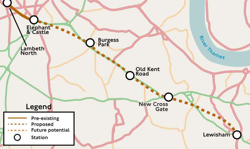
A map of the proposed London Underground Bakerloo line extension
Summary[edit]
| Description |
English: A map of the proposed London Underground Bakerloo line extension, see Bakerloo line extension |
| Date | |
| Source | Roads made with OpenStreetMap data, extracted using Maperative, Route map from [1] and [2] |
| Author | Own work by Isochrone |
| SVG development | This map was created with Adobe Illustrator. |
Licensing[edit]
This file is licensed under the Creative Commons Attribution-Share Alike 4.0 International license.
- You are free:
- to share – to copy, distribute and transmit the work
- to remix – to adapt the work
- Under the following conditions:
- attribution – You must give appropriate credit, provide a link to the license, and indicate if changes were made. You may do so in any reasonable manner, but not in any way that suggests the licensor endorses you or your use.
- share alike – If you remix, transform, or build upon the material, you must distribute your contributions under the same or compatible license as the original.
| This work contains information from OpenStreetMap, which is made available under the Open Database License (ODbL).
The ODbL does not require any particular license for maps produced from ODbL data. Prior to 1 August 2020, map tiles produced by the OpenStreetMap Foundation were licensed under the CC-BY-SA-2.0 license. Maps produced by other people may be subject to other licences. |
File history
Click on a date/time to view the file as it appeared at that time.
| Date/Time | Thumbnail | Dimensions | User | Comment | |
|---|---|---|---|---|---|
| current | 18:40, 24 December 2023 | | 993 × 593 (145 KB) | Isochrone (talk | contribs) | per talk |
| 19:41, 29 March 2021 |  | 512 × 310 (132 KB) | Isochrone (talk | contribs) | fix thames | |
| 19:32, 29 March 2021 |  | 512 × 310 (107 KB) | Isochrone (talk | contribs) | optimise | |
| 19:22, 29 March 2021 |  | 512 × 310 (152 KB) | Isochrone (talk | contribs) | spent so long trying to fix this– hopefully it works? | |
| 18:59, 29 March 2021 |  | 512 × 354 (379 KB) | Isochrone (talk | contribs) | god pain | |
| 18:47, 29 March 2021 |  | 512 × 354 (163 KB) | Isochrone (talk | contribs) | fix? | |
| 18:42, 29 March 2021 |  | 512 × 354 (175 KB) | Isochrone (talk | contribs) | Uploaded a work by {{u|Berrely}} from Roads made with OpenStreetMap data, extracted using Maperative, Route map from [https://consultations.tfl.gov.uk/tube/bakerloo-extension/user_uploads/ble-proposed-route.pdf] and [https://tfl.maps.arcgis.com/apps/webappviewer/index.html?id=1dac4606dcaa4bee98e6687b707abd49] with UploadWizard |
You cannot overwrite this file.
File usage on Commons
The following 8 pages use this file:
- User:Chumwa/OgreBot/Public transport information/2021 March 21-31
- User:Chumwa/OgreBot/Public transport information/2023 December 21-31
- User:Chumwa/OgreBot/Transport Maps/2021 March 21-31
- User:Chumwa/OgreBot/Transport Maps/2023 December 21-31
- User:Magog the Ogre/Multilingual legend/2021 March 21-31
- User:Magog the Ogre/Multilingual legend/2023 December 22-26
- User:Mattbuck/Railways/2021 March
- User:Mattbuck/Railways/2023 December
File usage on other wikis
The following other wikis use this file: