File:London Peak Trail (15690897200).jpg

Original file (1,920 × 1,080 pixels, file size: 2.25 MB, MIME type: image/jpeg)
Captions
Captions
Summary[edit]
.jpg&action=edit§ion=1)
| Description |
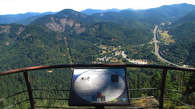
If you like to walk through groves of ancient trees, see a diversity of wildlife habitat, and enjoy a great workout then Lower London Peak Trail is for you. By the time you've completed this two mile hike, you will increase/decrease in elevation by over 1,400 feet. Interpretive signs are being installed and will provide an opportunity to rest while learning about the area. In October of 1998, London Peak Overlook Accessible Trail was dedicated. Just 20 minutes from the I-5 corridor, this ½ mile barrier free trail (rated moderately difficult for wheel-chair accessibility) meanders along a forested ridge line to the London Peak Overlook, offering spectacular views of the Rogue/Umpqua Divide, the Wolf Creek Canyon, and the historic Applegate Trail. London Peak is named after the famous American author Jack London who stayed at the Wolf Creek Inn, which is located in the community of Wolf Creek (also visible from the overlook). Use Season: Year Round Elevation: 2,835 feet Length: 2.5 Miles Difficulty: Moderate to Hard Activities: Hiking Directions: Take I-5, exit 76. Turn left, proceed under freeway. Go straight through intersection (stop sign) onto Bridge Lane. Drive two miles and turn right on BLM 33-6-26 (London Peak Rd.). Drive one mile to the first junction and turn right staying on 33-6-26. Continue to the left driving approximately two miles ending at the trailhead. (Follow sign to London Peak Trailhead). From North: Take I-5, exit 76. Proceed south through the community of Wolf Creek. Just before the south freeway on-ramp, turn right onto Bridge Lane. Drive two miles and turn right on BLM 33-6-26 (London Peak Rd.). Drive one mile to the first junction and turn right staying on 33-6-26. Continue to the left driving two miles ending at the trailhead. To earn more about this super-cool trail head on over to: <a href="http://blm.gov/v3ld" rel="nofollow">blm.gov/v3ld</a> |
| Date | |
| Source | London Peak Trail |
| Author | Bureau of Land Management Oregon and Washington from Portland, America |
Licensing[edit]
.jpg&action=edit§ion=2)
- You are free:
- to share – to copy, distribute and transmit the work
- to remix – to adapt the work
- Under the following conditions:
- attribution – You must give appropriate credit, provide a link to the license, and indicate if changes were made. You may do so in any reasonable manner, but not in any way that suggests the licensor endorses you or your use.
| This image was originally posted to Flickr by BLMOregon at https://flickr.com/photos/50169152@N06/15690897200 (archive). It was reviewed on 14 May 2018 by FlickreviewR 2 and was confirmed to be licensed under the terms of the cc-by-2.0. |
| This image is a work of a Bureau of Land Management* employee, taken or made as part of that person's official duties. As a work of the U.S. federal government, the image is in the public domain in the United States. *or predecessor organization |
File history
Click on a date/time to view the file as it appeared at that time.
| Date/Time | Thumbnail | Dimensions | User | Comment | |
|---|---|---|---|---|---|
| current | 00:30, 14 May 2018 | | 1,920 × 1,080 (2.25 MB) | OceanAtoll (talk | contribs) | Transferred from Flickr via #flickr2commons |
You cannot overwrite this file.
File usage on Commons
There are no pages that use this file.
.jpg&oldid=744143861)