File:Lohas park.svg

Original file (SVG file, nominally 734 × 644 pixels, file size: 205 KB)
Captions
Captions
| Description |
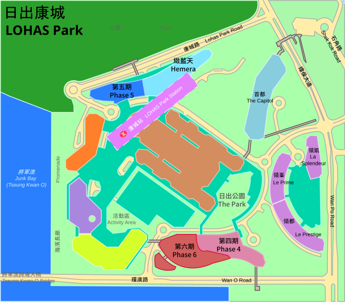
A simplified (and very preliminary*) map of LOHAS Park, Hong Kong, showing the locations of various parts of the complex. (Items with names grey in colour are still under planning) Version 1.2.1 * Please do not use the information from this map on serious matters. Contents are subject to change at any time. |
||
| Date | |||
| Source |
Drawn using Inkscape partly according to this plan, this plan, the model from this page, and many other sources. This W3C-unspecified vector image was created with Inkscape . |
||
| Author | zh:User:Moonian (i.e. Myself) | ||
| Permission (Reusing this file) |
I, the copyright holder of this work, hereby publish it under the following licenses:
This file is licensed under the Creative Commons Attribution-Share Alike 2.5 Generic license.
You may select the license of your choice. |

File history
Click on a date/time to view the file as it appeared at that time.
| Date/Time | Thumbnail | Dimensions | User | Comment | |
|---|---|---|---|---|---|
| current | 04:46, 16 December 2014 | | 734 × 644 (205 KB) | Wpcpey (talk | contribs) | {{Information |Description= |Source= |Date= |Author= |Permission= |other_versions= }} |
| 04:44, 16 December 2014 |  | 734 × 644 (183 KB) | Wpcpey (talk | contribs) | fixed text | |
| 04:42, 16 December 2014 |  | 734 × 644 (125 KB) | Wpcpey (talk | contribs) | updated 2014 vesion | |
| 03:38, 26 July 2014 |  | 734 × 644 (126 KB) | Jc86035 (talk | contribs) | Compressed using SVGCleaner | |
| 01:57, 16 September 2011 |  | 734 × 644 (152 KB) | Moonian (talk | contribs) | v.1.2.1: * Fixed: Phase 4 should be the whole of Package 3 instead of just half of it (Note: the layouts of Phases 3 and 4 are yet to be finalized) | |
| 07:43, 13 September 2011 |  | 734 × 644 (153 KB) | Moonian (talk | contribs) | v.1.2.0: * Phase 2 ** Redrawn the Phase according to new info ** Broke apart "Le Prestige" and "Le Prime" to become independent areas, but still keeping the original colours; also broke apart their corresponding tags ** Added the area for "La Splendeur" a | |
| 14:35, 6 October 2010 |  | 734 × 644 (142 KB) | Moonian (talk | contribs) | v.1.1.1: Added the name "Le Prime" together with the original "Le Prestige" | |
| 07:01, 19 April 2009 |  | 734 × 644 (139 KB) | Moonian (talk | contribs) | v.1.1.0: * Removed confusing names * Added the MTR station * Add the name of a road and made minor changes to the road itself * Updated the name of Package 2 * Fixed the English title | |
| 02:50, 22 March 2009 |  | 734 × 644 (165 KB) | Moonian (talk | contribs) | v.1.0.1: Added the name of a road | |
| 14:03, 23 October 2007 |  | 734 × 644 (158 KB) | Moonian (talk | contribs) | {{Information |Description=A simplified (and very preliminary*) map of Lohas Park, Hong Kong, showing the locations of various parts of the complex.<br />(Items with names <font color="#666666">grey</font> in colour are still under planning)<br />Version |
You cannot overwrite this file.
File usage on Commons
The following 2 pages use this file:
File usage on other wikis
The following other wikis use this file:
- Usage on en.wikipedia.org
- Usage on es.wikipedia.org
- Usage on ru.wikipedia.org
- Usage on zh-yue.wikipedia.org
- Usage on zh.wikipedia.org