File:Locuteurs de wolof au Sénégal.png
Jump to navigation
Jump to search
Size of this preview: 795 × 599 pixels. Other resolutions: 318 × 240 pixels | 637 × 480 pixels | 1,000 × 754 pixels.
Original file (1,000 × 754 pixels, file size: 220 KB, MIME type: image/png)
Captions
Captions
Add a one-line explanation of what this file represents

|
This linguistic map image could be re-created using vector graphics as an SVG file. This has several advantages; see Commons:Media for cleanup for more information. If an SVG form of this image is available, please upload it and afterwards replace this template with
{{vector version available|new image name}}.
It is recommended to name the SVG file “Locuteurs de wolof au Sénégal.svg”—then the template Vector version available (or Vva) does not need the new image name parameter. |
| Description |
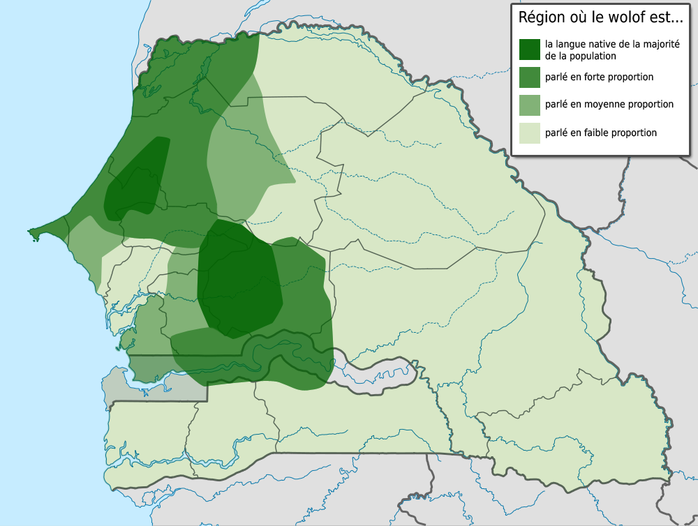
Français : Locuteurs de wolof au Sénégal selon le Dictionnaire wolof-français par Arame Fal, Rosine Santos et Jean Léonce Doneux, Karthala, Paris 1990
English: Wolof speakers according to the Dictionnaire wolof-français cited above. Categories go from darkest to lightest:
|
| Date | (UTC) |
| Source |
|
| Author |
|
| This is a retouched picture, which means that it has been digitally altered from its original version. Modifications: Added speaker density data. The original can be viewed here: Senegal location map.svg:
|
I, the copyright holder of this work, hereby publish it under the following license:
This file is licensed under the Creative Commons Attribution-Share Alike 3.0 Unported license.
- You are free:
- to share – to copy, distribute and transmit the work
- to remix – to adapt the work
- Under the following conditions:
- attribution – You must give appropriate credit, provide a link to the license, and indicate if changes were made. You may do so in any reasonable manner, but not in any way that suggests the licensor endorses you or your use.
- share alike – If you remix, transform, or build upon the material, you must distribute your contributions under the same or compatible license as the original.
Original upload log[edit]
This image is a derivative work of the following images:
- File:Senegal_location_map.svg licensed with Cc-by-sa-3.0
- 2009-09-15T20:56:02Z NordNordWest 1266x954 (477807 Bytes)
- 2009-09-15T15:34:57Z NordNordWest 1266x954 (479064 Bytes) =={{int:filedesc}}== {{Information |Description= {{de|Positionskarte von [[:de:Senegal|Senegal]]}} Quadratische Plattkarte, N-S-Streckung 103 %. Geographische Begrenzung der Karte: * N: 16.9° N * S: 12.0° N * W: 17.8° W *
Uploaded with derivativeFX
File history
Click on a date/time to view the file as it appeared at that time.
| Date/Time | Thumbnail | Dimensions | User | Comment | |
|---|---|---|---|---|---|
| current | 07:58, 19 January 2011 | | 1,000 × 754 (220 KB) | Yaamboo (talk | contribs) | {{Information |Description={{fr|Locuteurs de wolof au Sénégal selon le Dictionnaire wolof-français par Arame Fal, Rosine Santos et Jean Léonce Doneux, Karthala, Paris 1990}} {{en|Wolof speakers according to the Dictionnaire wolof-français cited above |
You cannot overwrite this file.
File usage on Commons
The following page uses this file:
File usage on other wikis
The following other wikis use this file:
- Usage on fr.wikipedia.org
- Usage on pl.wikipedia.org
- Usage on ru.wikipedia.org