File:Locations in north Britain in the early tenth century.png
Jump to navigation
Jump to search
No higher resolution available.
Locations_in_north_Britain_in_the_early_tenth_century.png (385 × 600 pixels, file size: 166 KB, MIME type: image/png)
Captions
Captions
Add a one-line explanation of what this file represents
Summary[edit]
| Description | Work derived from Image:Scotland Land Use by height.png. Licensing per that image. Created by user:SFC9394. Licensed CCSA2.5 and GFDL per original work. |
| Date | 2006-04-16, this modified version 2007-05-12 |
| Source | From Image:Scotland Land Use by height.png |
| Author | SFC9394 |
Licensing[edit]
This file is licensed under the Creative Commons Attribution-Share Alike 2.5 Generic license.
- You are free:
- to share – to copy, distribute and transmit the work
- to remix – to adapt the work
- Under the following conditions:
- attribution – You must give appropriate credit, provide a link to the license, and indicate if changes were made. You may do so in any reasonable manner, but not in any way that suggests the licensor endorses you or your use.
- share alike – If you remix, transform, or build upon the material, you must distribute your contributions under the same or compatible license as the original.
SFC9394 at the English-language Wikipedia, the copyright holder of this work, hereby publishes it under the following license:
| This file is licensed under the Creative Commons Attribution-Share Alike 3.0 Unported license. Subject to disclaimers. | ||
| Attribution: SFC9394 at the English-language Wikipedia | ||
| ||
| This licensing tag was added to this file as part of the GFDL licensing update. |

|
Permission is granted to copy, distribute and/or modify this document under the terms of the GNU Free Documentation License, Version 1.2 or any later version published by the Free Software Foundation; with no Invariant Sections, no Front-Cover Texts, and no Back-Cover Texts. A copy of the license is included in the section entitled GNU Free Documentation License. Subject to disclaimers. |
Original Description[edit]
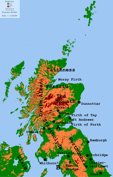
Map of Scotland showing three height graduations (<200m, 200-600m, 600m+) for use in describing land usage, as requested by Angus McLellan
Height data derived from NASA SRTM and GTOPO30, both PD.
Map key[edit]
The map shows some locations mentioned in late C9th/early C10th sources.
The lines marked A and B are:
- A: the approximate southern boundary of the en:Kingdom of Alba, c. 900–950
- B: the approximate southern boundary of the en:Kingdom of Strathclyde, at about 927.
All locations are approximate.
File history
Click on a date/time to view the file as it appeared at that time.
| Date/Time | Thumbnail | Dimensions | User | Comment | |
|---|---|---|---|---|---|
| current | 15:41, 19 August 2010 | | 385 × 600 (166 KB) | Mahahahaneapneap (talk | contribs) | Compressed |
| 13:35, 9 December 2007 |  | 385 × 600 (209 KB) | Angusmclellan (talk | contribs) | {{Information |Description= |Source= |Date= |Author= |Permission= |other_versions= }} | |
| 20:38, 6 December 2007 |  | 385 × 600 (204 KB) | Angusmclellan (talk | contribs) | ||
| 23:21, 5 December 2007 |  | 308 × 480 (139 KB) | Angusmclellan (talk | contribs) | {{Information |Description=Work derived from Image:Scotland Land Use by height.png. Licensing per that image. Created by user:SFC9394. Licensed CCSA2.5 and GFDL per original work. |Source=From Image:Scotland Land Use by height.png |Date=200 |
You cannot overwrite this file.
File usage on Commons
There are no pages that use this file.
File usage on other wikis
The following other wikis use this file:
- Usage on el.wikipedia.org
- Usage on en.wikipedia.org
- Usage on fr.wikipedia.org
- Usage on hu.wikipedia.org
- Usage on no.wikipedia.org