File:Location of lands administered by the NPS (ea8841ea-c889-4bf2-96c4-22cfb085f520).jpg

Original file (4,250 × 5,500 pixels, file size: 1.43 MB, MIME type: image/jpeg)
Captions
Captions
Summary[edit]
.jpg&action=edit§ion=1)
| English: MISS Lands | ||||
|---|---|---|---|---|
| Photographer |
English: NPS |
|||
| Title |
English: MISS Lands |
|||
| Description |
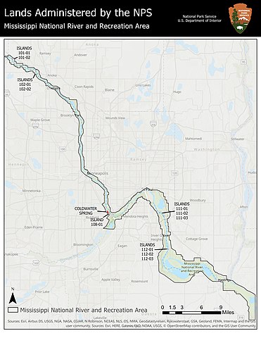
English: Transit map of central MN and the MN metropolitan area. Mississippi National River and Recreation Area boundary generally follows the Mississippi River Boundary from Dayton, MN in the north westernmost section of the park, down past Hastings, MN by approximately 7 miles. NPS-owned islands are highlighted with 101-01 & 02 near Dayton, MN; 102-01 & 02 near Anoka, MN; 108-01 and Coldwater Spring north of the MSP International Airport; 111-01, 02, & 03 just south of St Paul, MN; and 112-01, 02 & 03 near Inver Grove Heights, MN. Location of lands administered by the NPS
|
|||
| Depicted place |
English: Mississippi National River and Recreation Area, Minnesota |
|||
| Accession number | ||||
| Source |
English: NPGallery |
|||
| Permission (Reusing this file) |
|
|||
| NPS Unit Code | MISS | |||
File history
Click on a date/time to view the file as it appeared at that time.
| Date/Time | Thumbnail | Dimensions | User | Comment | |
|---|---|---|---|---|---|
| current | 20:01, 16 January 2022 | | 4,250 × 5,500 (1.43 MB) | BMacZeroBot (talk | contribs) | Batch upload (Commons:Batch uploading/NPGallery) |
You cannot overwrite this file.
File usage on Commons
The following page uses this file:
.jpg)
.jpg&oldid=737018344)