File:Location map Spain Tenerife.png
Jump to navigation
Jump to search

Size of this preview: 685 × 600 pixels. Other resolutions: 274 × 240 pixels | 548 × 480 pixels | 796 × 697 pixels.
Original file (796 × 697 pixels, file size: 194 KB, MIME type: image/png)
Captions
Captions
Add a one-line explanation of what this file represents
| Description |
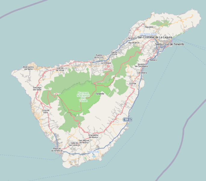
English: Map of Tenerife
Geographic limits of the map:
This file is licensed under the Creative Commons Attribution-Share Alike 2.0 Generic license.
|
| Source | OpenStreetMap |
| Author | Dr. Blofeld |
File history
Click on a date/time to view the file as it appeared at that time.
| Date/Time | Thumbnail | Dimensions | User | Comment | |
|---|---|---|---|---|---|
| current | 17:29, 2 May 2010 | | 796 × 697 (194 KB) | Dr. Blofeld~commonswiki (talk | contribs) | {{Information |Description={{en|1=l}} |Source=l |Author=l |Date=l |Permission= |other_versions= }} |
You cannot overwrite this file.
File usage on Commons
There are no pages that use this file.
File usage on other wikis
The following other wikis use this file:
- Usage on ar.wikipedia.org
- Usage on azb.wikipedia.org
- Usage on ca.wikipedia.org
- Usage on ceb.wikipedia.org
- Usage on cs.wikipedia.org
- Usage on el.wikipedia.org
- Usage on en.wikipedia.org
- Santa Cruz de Tenerife
- Los Realejos
- Icod de los Vinos
- Arona, Tenerife
- Granadilla de Abona
- Güímar
- San Cristóbal de La Laguna
- El Rosario, Tenerife
- Candelaria, Tenerife
- Arafo
- Arico
- Adeje
- Guía de Isora
- Buenavista del Norte
- Garachico
- La Guancha, Tenerife
- San Juan de la Rambla, Santa Cruz de Tenerife
- La Orotava
- La Matanza de Acentejo
- Los Cristianos
- Turespaña Open De Canaria
- Teide National Park
- Abama Open de Canarias
- Tenerife Espacio de las Artes
- Playa de Las Teresitas
- Castle of San Cristóbal (Santa Cruz de Tenerife)
- Puerto de la Cruz
- Punta de Anaga Lighthouse
- Punta Abona Lighthouse
- Punta Rasca Lighthouse
- Punta de Teno Lighthouse
- Puerto de la Cruz Lighthouse
View more global usage of this file.