File:LocationUnitedArabRepublic2.png
Jump to navigation
Jump to search
No higher resolution available.
LocationUnitedArabRepublic2.png (250 × 115 pixels, file size: 20 KB, MIME type: image/png)
Captions
Captions
Add a one-line explanation of what this file represents
| Description |
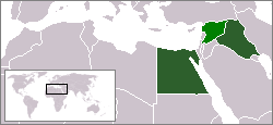
Deutsch: Karte der Vereinigten Arabischen Republik von 1963, einer ehemals geplanten Föderation zwischen Ägypten, dem Irak und Syrien.
English: Map of the United Arab Republic, a former planned federation between Egypt, Iraq and Syria in 1963. |
| Date | |
| Source | Own work |
| Author | JCIV |

|
Permission is granted to copy, distribute and/or modify this document under the terms of the GNU Free Documentation License, Version 1.2 or any later version published by the Free Software Foundation; with no Invariant Sections, no Front-Cover Texts, and no Back-Cover Texts. A copy of the license is included in the section entitled GNU Free Documentation License. |
| This file is licensed under the Creative Commons Attribution-Share Alike 3.0 Unported license. | ||
| ||
| This licensing tag was added to this file as part of the GFDL licensing update. |
File history
Click on a date/time to view the file as it appeared at that time.
| Date/Time | Thumbnail | Dimensions | User | Comment | |
|---|---|---|---|---|---|
| current | 16:41, 14 January 2017 | | 250 × 115 (20 KB) | عادل (talk | contribs) | Correction of Egypt borders |
| 17:19, 6 February 2010 |  | 250 × 115 (6 KB) | SpesBona (talk | contribs) | Make Syria in darker green | |
| 13:55, 6 February 2010 |  | 250 × 115 (6 KB) | SpesBona (talk | contribs) | {{Information |Description={{en|1=Map of the United Arab Republic, a union between Egypt, Iraq and Syria in 1963. {{GFDL|migration=relicense}}}} |Source={{own}} |Author=JCIV |Date=2010-02-06 |Permission= |other_versions= }} [[C |
You cannot overwrite this file.
File usage on Commons
The following page uses this file:
File usage on other wikis
The following other wikis use this file:
- Usage on af.wikipedia.org
- Usage on ar.wikipedia.org
- Usage on de.wikipedia.org
- Usage on ru.wikipedia.org
- Usage on www.wikidata.org