File:LocationHungaryInterbellum.png
Jump to navigation
Jump to search
No higher resolution available.
LocationHungaryInterbellum.png (248 × 113 pixels, file size: 6 KB, MIME type: image/png)
Captions
Captions
Add a one-line explanation of what this file represents
Summary[edit]
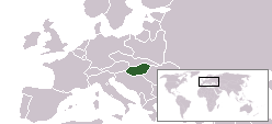
| Description | Location of Hungary during 1920s and 1930s |
| Source | based on Image:LocationCzechoslovakia.png |
| Author | Hanhil |
Licensing[edit]
| I, the copyright holder of this work, release this work into the public domain. This applies worldwide. In some countries this may not be legally possible; if so: I grant anyone the right to use this work for any purpose, without any conditions, unless such conditions are required by law. |
File history
Click on a date/time to view the file as it appeared at that time.
| Date/Time | Thumbnail | Dimensions | User | Comment | |
|---|---|---|---|---|---|
| current | 07:59, 20 April 2008 | | 248 × 113 (6 KB) | Hanhil (talk | contribs) | {{Information |Description=Location of Hungary during 1920s and 1930s |Source=based on Image:LocationCzechoslovakia.png |Date= |Author= Hanhil |Permission= |other_versions= }} Category:Maps of the history of Hungary |
You cannot overwrite this file.
File usage on Commons
The following page uses this file:
File usage on other wikis
The following other wikis use this file:
- Usage on ca.wikipedia.org
- Usage on hr.wikipedia.org
- Usage on nl.wikipedia.org
- Usage on rue.wikipedia.org