File:Lloyd's Map of the Southern States 1861 UTA.jpg

Original file (4,568 × 3,320 pixels, file size: 11 MB, MIME type: image/jpeg)
Captions
Captions
Summary[edit]
| Title |
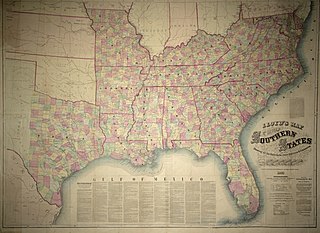
English: Lloyd's Map of the Southern States Showing all the Railroads, their Stations & Distances also the Counties, Towns, Villages, Harbors, Rivers, and Forts |
||||||||||||||||||||||||||
| Description |
English: The vast majority of war-related maps of the United States produced during the Civil War did not reference the West. At least some, like this commercial "military map", included part of Texas, which, after all, was one of the seceding states, although not often acknowledged as an important potential battleground.
In the first year of the war, James T. Lloyd of London and New York published an update of his 1859 railroad map of the United States, a large "$100,000 Topographical Map of the State of Virginia", and this one, which, according to his own text on the back, had been already "...started one year ago, long before the present troubles began. It was drawn from actual surveys made by southern surveyors, and the only reliable Map of the Southern States now offered to the people...." While Lloyd claimed that he and his firm had used all the latest information (railroad surveys, the recent 1860 census, historical works on Virginia and Missouri, and the official reports of the Coast Surveys), at least some of his information on Texas was of poor quality and already out of date. For example, he located two forts in the southern panhandle (Forts McKavett and Terrett) when they were actually hundreds of miles south and had been abandoned in 1859 and 1854, respectively. The county configurations, which here are hand colored and supposedly up-to-date for Virginia and Missouri, do not include the Texas counties created in 1860. Lloyd's map does, nonetheless, accurately show the completed and projected railroads for the state as of 1861. The only battle sites noted in Texas are "Fort Alamo" at San Antonio and, surprisingly, "Kings" with crossed sabers in Refugio County – the latter a reference to the Battle of Refugio and the capture of Amon B. King's command in 1836 during the Texas War for Independence. It is notable that Lloyd had a tendency to fill much of the available spaces on his maps – both front and back – with hyperbolic text to enhance and promote his own maps, criticize his competitors, and, on occasion, to record irrelevant commentary. |
||||||||||||||||||||||||||
| Date | |||||||||||||||||||||||||||
| Source | UTA Libraries Cartographic Connections: map / text | ||||||||||||||||||||||||||
| Creator |
James T. Lloyd |
||||||||||||||||||||||||||
| Credit line |
English: UTA Libraries Special Collections, from the Henry W. Benham Family Collection |
||||||||||||||||||||||||||
| Geotemporal data | |||||||||||||||||||||||||||
| Map location | United States of America | ||||||||||||||||||||||||||
| Georeferencing | If inappropriate please set warp_status = skip to hide. | ||||||||||||||||||||||||||
| Bibliographic data | |||||||||||||||||||||||||||
| Place of publication | New York City | ||||||||||||||||||||||||||
| Printed by |
James T. Lloyd |
||||||||||||||||||||||||||
| Archival data | |||||||||||||||||||||||||||
| Collection |
|
||||||||||||||||||||||||||
| Dimensions | height: 95 cm (37.4 in); width: 130 cm (51.1 in) | ||||||||||||||||||||||||||
| Medium | colored photolithography | ||||||||||||||||||||||||||
| artwork-references |
Stephenson, Richard W. (1989) Civil War Maps: An Annotated List of Maps and Atlases in the Library of Congress (2nd ed.), Washington, D.C.: Library of Congress, p. 35 McElfresh, Earl B. (1999) Maps and Mapmakers of the Civil War, New York City: Harry N. Abrams, Inc., p. 16 |
||||||||||||||||||||||||||
Licensing[edit]

|
This file was provided to Wikimedia Commons by the University of Texas at Arlington Libraries as part of a cooperation project. The University of Texas at Arlington Libraries is part of the University of Texas at Arlington, a public research university located in Arlington, Texas.
|
|
The author died in 1867, so this work is in the public domain in its country of origin and other countries and areas where the copyright term is the author's life plus 100 years or fewer. This work is in the public domain in the United States because it was published (or registered with the U.S. Copyright Office) before January 1, 1929. | |
| This file has been identified as being free of known restrictions under copyright law, including all related and neighboring rights. | |
File history
Click on a date/time to view the file as it appeared at that time.
| Date/Time | Thumbnail | Dimensions | User | Comment | |
|---|---|---|---|---|---|
| current | 21:06, 17 March 2022 | | 4,568 × 3,320 (11 MB) | Michael Barera (talk | contribs) | == {{int:filedesc}} == {{Map |title = {{en|'''''Lloyd's Map of the Southern States Showing all the Railroads, their Stations & Distances also the Counties, Towns, Villages, Harbors, Rivers, and Forts'''''}} |description = {{en|The vast majority of war-related maps of the United States produced during the Civil War did not reference the West. At least some, like this commercial "military map", included part of Texas, which, after all, was one of the seceding states, althoug... |
You cannot overwrite this file.
File usage on Commons
The following page uses this file: