File:LithuaniaPhysicalMap-Detailed.png
Jump to navigation
Jump to search

Size of this preview: 800 × 566 pixels. Other resolutions: 320 × 227 pixels | 640 × 453 pixels | 1,024 × 725 pixels | 1,280 × 906 pixels | 2,366 × 1,675 pixels.
Original file (2,366 × 1,675 pixels, file size: 2.41 MB, MIME type: image/png)
Captions
Captions
Add a one-line explanation of what this file represents
Summary[edit]
| Description |
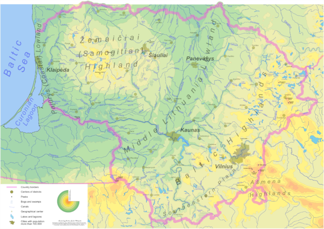
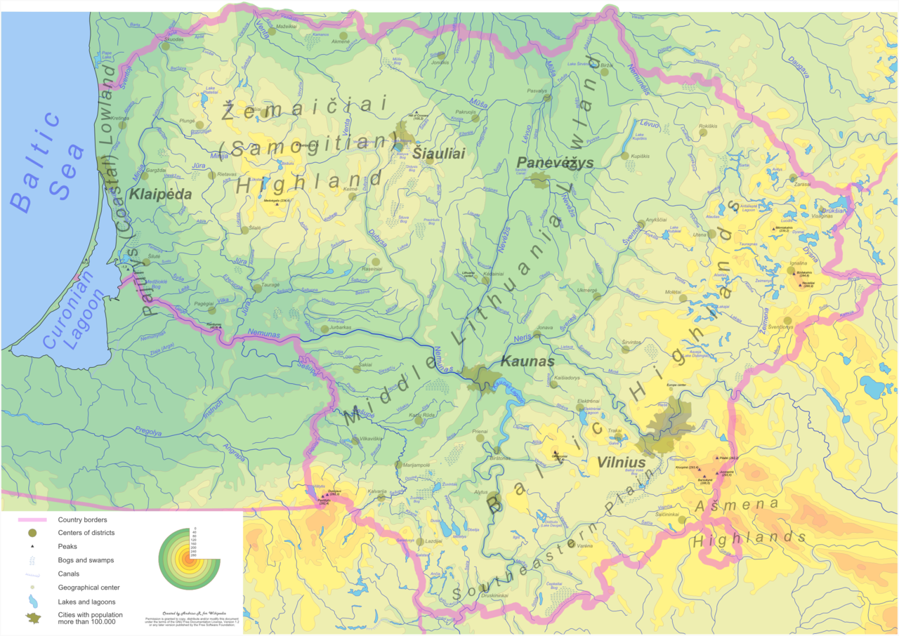
Detailed Lithuania physical map with major cities, lakes, rivers, swamps highlighted English: Physical map of Lithuania. Click on the image for better resolution. |
| Date | between 2005 and 2006 |
| Source | digitized various sources |
| Author | Andrius Ramanauskas |
| Permission (Reusing this file) |
GFDL |
| Other versions | vectoric source - Image:LithuaniaPhysicalMap-Detailed.svg |
Many thanks to Renata for support and multiple reviews, comments and suggstions
Licensing[edit]
I, the copyright holder of this work, hereby publish it under the following licenses:

|
Permission is granted to copy, distribute and/or modify this document under the terms of the GNU Free Documentation License, Version 1.2 or any later version published by the Free Software Foundation; with no Invariant Sections, no Front-Cover Texts, and no Back-Cover Texts. A copy of the license is included in the section entitled GNU Free Documentation License. |
| This file is licensed under the Creative Commons Attribution-Share Alike 3.0 Unported license. | ||
| ||
| This licensing tag was added to this file as part of the GFDL licensing update. |
This file is licensed under the Creative Commons Attribution-Share Alike 2.5 Generic, 2.0 Generic and 1.0 Generic license.
- You are free:
- to share – to copy, distribute and transmit the work
- to remix – to adapt the work
- Under the following conditions:
- attribution – You must give appropriate credit, provide a link to the license, and indicate if changes were made. You may do so in any reasonable manner, but not in any way that suggests the licensor endorses you or your use.
- share alike – If you remix, transform, or build upon the material, you must distribute your contributions under the same or compatible license as the original.
You may select the license of your choice.
File history
Click on a date/time to view the file as it appeared at that time.
| Date/Time | Thumbnail | Dimensions | User | Comment | |
|---|---|---|---|---|---|
| current | 06:12, 5 June 2006 | | 2,366 × 1,675 (2.41 MB) | Knutux (talk | contribs) | updated version |
| 14:24, 3 May 2006 |  | 2,366 × 1,675 (2.51 MB) | Knutux (talk | contribs) | updating once more by comments | |
| 13:25, 26 April 2006 |  | 2,366 × 1,675 (2.53 MB) | Knutux (talk | contribs) | updated version (more river/city names, small corrections) | |
| 05:40, 16 March 2006 |  | 3,548 × 2,512 (4.11 MB) | Knutux (talk | contribs) | updated version (more details added - mostly river names) | |
| 13:26, 10 March 2006 |  | 3,548 × 2,512 (3.86 MB) | Knutux (talk | contribs) | new version | |
| 07:34, 9 March 2006 |  | 4,731 × 3,349 (6.05 MB) | Knutux (talk | contribs) | Detailed Lithuania physical map with major cities, lakes, rivers, swamps highlighted (work in progress) |
You cannot overwrite this file.
File usage on Commons
The following 3 pages use this file:
File usage on other wikis
The following other wikis use this file:
- Usage on ast.wikipedia.org
- Usage on az.wikipedia.org
- Usage on be.wikipedia.org
- Usage on bn.wikipedia.org
- Usage on da.wikipedia.org
- Usage on de.wikipedia.org
- Usage on en.wikipedia.org
- Usage on es.wikipedia.org
- Usage on fa.wikipedia.org
- Usage on fi.wikipedia.org
- Usage on fr.wikipedia.org
- Usage on hr.wikipedia.org
- Usage on it.wikipedia.org
- Usage on ja.wikipedia.org
- Usage on ka.wikipedia.org
- Usage on ku.wikipedia.org
- Usage on lt.wikipedia.org
- Usage on mk.wikipedia.org
- Usage on nn.wikipedia.org
- Usage on no.wikipedia.org
- Usage on pl.wikipedia.org
- Usage on pt.wikipedia.org
- Usage on ro.wikipedia.org
- Usage on ru.wikipedia.org
- Usage on ru.wikimedia.org
- Usage on sco.wikipedia.org
- Usage on simple.wikipedia.org
- Usage on sk.wikipedia.org
- Usage on sr.wikipedia.org
- Usage on tl.wikipedia.org
- Usage on tr.wikipedia.org
- Usage on uk.wikipedia.org
View more global usage of this file.