File:Linné crater color coded shaded relief map detail.png

Original file (860 × 860 pixels, file size: 1.27 MB, MIME type: image/png)
Captions
Captions
| Description |
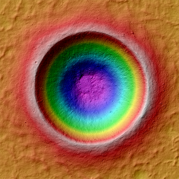
Barnstorming Linné crater: Color coded shaded relief map of Linné crater (2.2 km diameter) created from an LROC NAC stereo topographic model. The colors represent elevations; cool colors are lowest and hot colors are highest. Linné (2.2 km diameter) is a very young and beautifully preserved impact crater. LROC stereo images provide scientists with the third dimension - information critical for unraveling the physics involved in impact events. The LROC science team presented a first analysis of Linné crater topology at the Lunar and Planetary Science Conference last week. The high resolution topographic model also provides the means to make synthetic views of the crater from any angle. By creating hundreds of such views and slightly changing the view point for each image a dramatic fly around movie appears on the screen! |
|||||
| Date | ||||||
| Source | description, file | |||||
| Author | NASA/GSFC/Arizona State University | |||||
| Permission (Reusing this file) |
|
|||||
| Other versions |
 |

File history
Click on a date/time to view the file as it appeared at that time.
| Date/Time | Thumbnail | Dimensions | User | Comment | |
|---|---|---|---|---|---|
| current | 10:11, 7 September 2011 | | 860 × 860 (1.27 MB) | Badseed (talk | contribs) | {{Information |Description=Barnstorming Linné crater: Color coded shaded relief map of Linné crater (2.2 km diameter) created from an LROC NAC stereo topographic model. The colors represent elevations; cool colors are lowest and hot colors are highest. |
You cannot overwrite this file.
File usage on Commons
The following 3 pages use this file:
.png)
File usage on other wikis
The following other wikis use this file:
- Usage on en.wikipedia.org
- Usage on ru.wikipedia.org
- Usage on zh.wikipedia.org