File:Ligne D (avec stations).png
Jump to navigation
Jump to search
Size of this preview: 800 × 434 pixels. Other resolutions: 320 × 174 pixels | 640 × 347 pixels | 1,024 × 555 pixels | 1,280 × 694 pixels | 2,004 × 1,087 pixels.
Original file (2,004 × 1,087 pixels, file size: 4.1 MB, MIME type: image/png)
Captions
Captions
Add a one-line explanation of what this file represents
Summary[edit]
.png&action=edit§ion=1)
| Description |
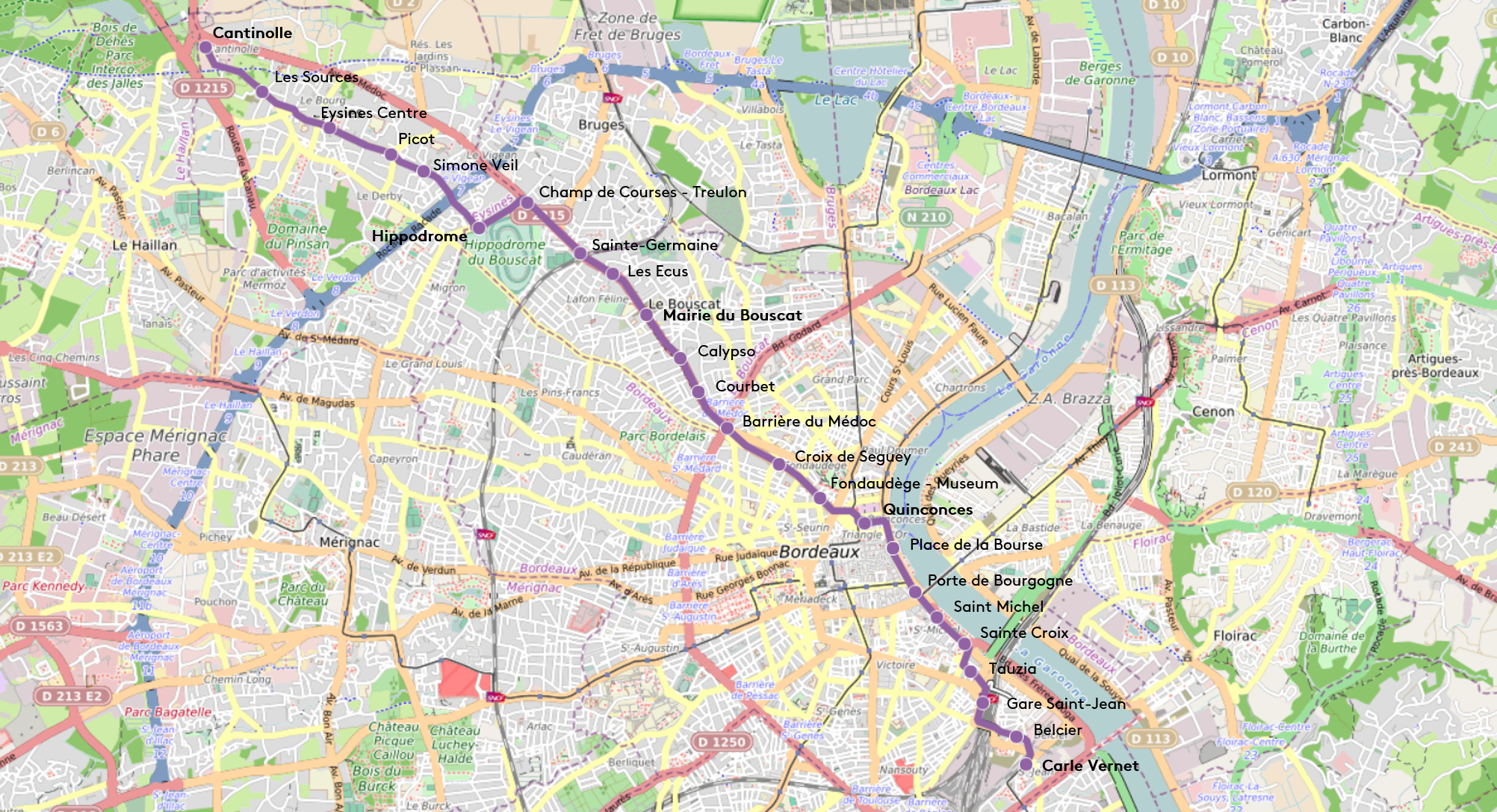
Français : Cette carte représente la ligne D du tramway de Bordeaux. |
| Date | |
| Source | Own work |
| Author | Vince034 |
Licensing[edit]
.png&action=edit§ion=2)
I, the copyright holder of this work, hereby publish it under the following license:
This file is licensed under the Creative Commons Attribution-Share Alike 4.0 International license.
- You are free:
- to share – to copy, distribute and transmit the work
- to remix – to adapt the work
- Under the following conditions:
- attribution – You must give appropriate credit, provide a link to the license, and indicate if changes were made. You may do so in any reasonable manner, but not in any way that suggests the licensor endorses you or your use.
- share alike – If you remix, transform, or build upon the material, you must distribute your contributions under the same or compatible license as the original.
File history
Click on a date/time to view the file as it appeared at that time.
| Date/Time | Thumbnail | Dimensions | User | Comment | |
|---|---|---|---|---|---|
| current | 22:13, 27 December 2019 | | 2,004 × 1,087 (4.1 MB) | Vince034 (talk | contribs) | Retrait de l'extension vers SM - tracé, stations et date d'ouverture incertains |
| 14:37, 8 December 2019 |  | 1,920 × 1,125 (3.97 MB) | Vince034 (talk | contribs) | La ligne D passe du vert au violet ! simple modification | |
| 22:52, 29 December 2018 |  | 1,891 × 1,138 (4.08 MB) | Vince034 (talk | contribs) | ajout tronc commun ligne C. | |
| 22:48, 29 December 2018 |  | 1,502 × 898 (2.63 MB) | Vince034 (talk | contribs) | Reverted to version as of 19:28, 16 July 2018 (UTC) | |
| 13:54, 29 December 2018 |  | 1,891 × 1,138 (4.08 MB) | Vince034 (talk | contribs) | Ajout tronc commun ligne C | |
| 19:28, 16 July 2018 |  | 1,502 × 898 (2.63 MB) | Vince034 (talk | contribs) | Correction nom de la station champ de courses - treulon | |
| 17:54, 16 July 2018 |  | 1,502 × 897 (2.63 MB) | Vince034 (talk | contribs) | User created page with UploadWizard |
You cannot overwrite this file.
File usage on Commons
The following 14 pages use this file:
- User:Chumwa/OgreBot/Potential transport maps/2018 December 21-31
- User:Chumwa/OgreBot/Potential transport maps/2018 July 11-20
- User:Chumwa/OgreBot/Potential transport maps/2019 December 1-10
- User:Chumwa/OgreBot/Potential transport maps/2019 December 21-31
- User:Chumwa/OgreBot/Public transport information/2018 December 21-31
- User:Chumwa/OgreBot/Public transport information/2018 July 11-20
- User:Chumwa/OgreBot/Public transport information/2019 December 1-10
- User:Chumwa/OgreBot/Public transport information/2019 December 21-31
- User:Chumwa/OgreBot/Transport Maps/2018 December 21-31
- User:Chumwa/OgreBot/Transport Maps/2018 July 11-20
- User:Chumwa/OgreBot/Transport Maps/2019 December 1-10
- User:Chumwa/OgreBot/Transport Maps/2019 December 21-31
- User:Chumwa/OgreBot/Travel and communication maps/2018 December 21-31
- User:Chumwa/OgreBot/Travel and communication maps/2018 July 11-20
.png&oldid=518585510)