File:Lexington Concord Siege of Boston crop.jpg
Original file (2,861 × 2,188 pixels, file size: 1.89 MB, MIME type: image/jpeg)
Captions
Captions
Summary[edit]
| Description |
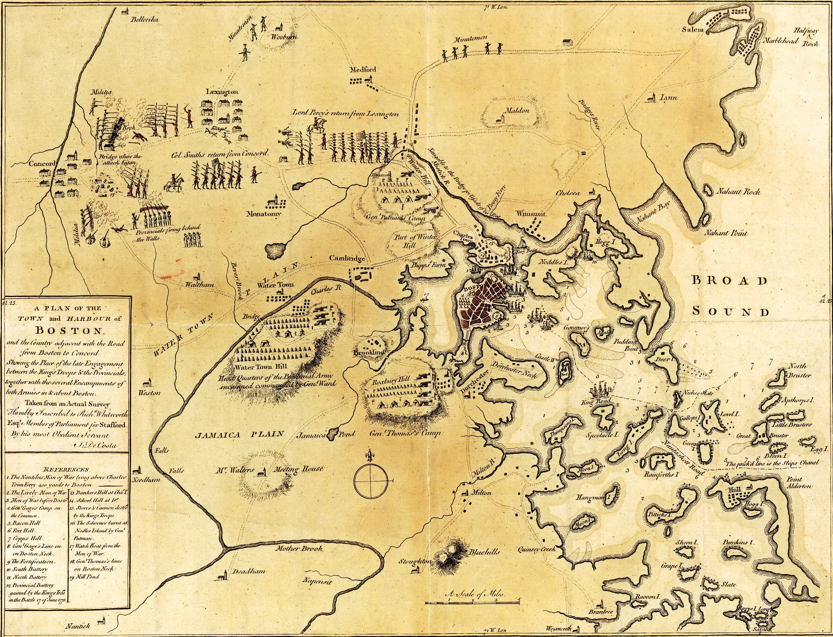
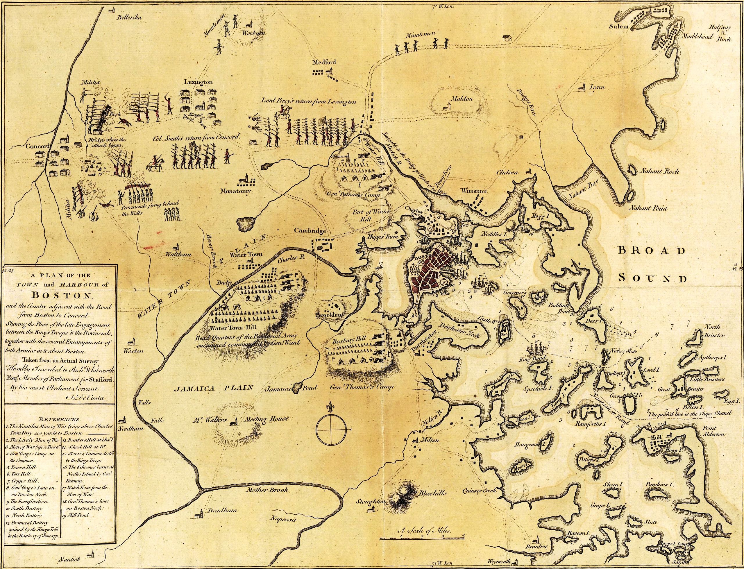
English: A mostly accurate hand-colored map depicting the 1775 Battles of Lexington and Concord and the Siege of Boston |
| Date | |
| Source |
From the Library of Congress American Memory. |
| Author | J. DeCosta |
| Other versions |
 |
Large text box[edit]
TOWN and HARBOUR of
Boston.
and the Country adjacent with the Road
from Boston to Concord
Shewing the Place of the late Engagement
between the King's Troops & the Provincials,
together with the several Encampments of
both Armies in & about Boston.
Taken from an Actual Survey
Humbly Inscribed to Rich d. Whitworth
Esqr. Member of Parliament for Stafford
Legend[edit]
References.
- The Nautilus Man of War lying above Charles
- Town Ferry 400 yards to Boston
- The Lively Man of War
- Men of War before Boston.
- Gen l. Gage's Camp on
- the Common.
- Bacon Hill [i.e. Beacon Hill]
- Fort Hill.
- Copps Hill.
- Gen l. Gage's Line on
- on Boston Neck.
- The Fortification.
- South Battery
- North Battery
- Provincial Battery
- gained by the King's Troo ps
- in the Battle 17 of June 1775
- Bunkers Hill at Cha s. T.
- School Hill at D o.
- Stores & Cannon destro d
- by the King's Troops
- The Schooner burnt at
- Nodles Island by Gen l.
- Putman
- Watch Boat from the Men of War.
- Gen l. Thomas's lines
- on Boston Neck
- Mill Pond
Text along the bottom[edit]
- London Publish'd as the Act directs July 29th. 1775 by J. De Costa Red Croſs Street Southwark.

|
This map is available from the United States Library of Congress's Geography & Map Division
under the digital ID g3764b.ar090000. This tag does not indicate the copyright status of the attached work. A normal copyright tag is still required. See Commons:Licensing.
|
|
This work is in the public domain in its country of origin and other countries and areas where the copyright term is the author's life plus 100 years or fewer. | |
| This file has been identified as being free of known restrictions under copyright law, including all related and neighboring rights. | |
File history
Click on a date/time to view the file as it appeared at that time.
| Date/Time | Thumbnail | Dimensions | User | Comment | |
|---|---|---|---|---|---|
| current | 03:00, 4 July 2014 | | 2,861 × 2,188 (1.89 MB) | Beyond My Ken (talk | contribs) | == {{int:filedesc}} == {{Information |author=J. DeCosta |date=1775-07-29 |description={{en|A mostly accurate hand-colored map depicting the 1775 Battles of Lexington and Concord and the [[w:Siege of Boston|Siege o... |
You cannot overwrite this file.
File usage on Commons
The following page uses this file:
File usage on other wikis
The following other wikis use this file:
- Usage on azb.wikipedia.org
- Usage on cs.wikipedia.org
- Usage on en.wikipedia.org
- Usage on it.wikipedia.org
- Usage on ru.wikipedia.org
Metadata
- Old maps of the American Revolution
- Battles of Lexington and Concord
- Military maps
- Maps of sieges
- Fort Hill (Boston)
- South Battery (Boston)
- Maps in the Library of Congress
- Maps of the Battle of Bunker Hill
- 1775 maps of Boston
- Siege of Boston
- Maps of the Boston Campaign
- American Revolutionary War encampments
- Charles River in the 18th century
- Maps of the Charles River