File:Map Crusader states 1240-it.svg
(Redirected from File:Levante 1240-it.svg)

Size of this PNG preview of this SVG file: 440 × 599 pixels. Other resolutions: 176 × 240 pixels | 353 × 480 pixels | 564 × 768 pixels | 752 × 1,024 pixels | 1,505 × 2,048 pixels | 507 × 690 pixels.
Original file (SVG file, nominally 507 × 690 pixels, file size: 699 KB)
Captions
Captions
Add a one-line explanation of what this file represents
| Description |
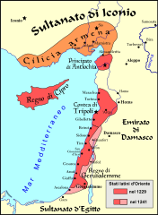
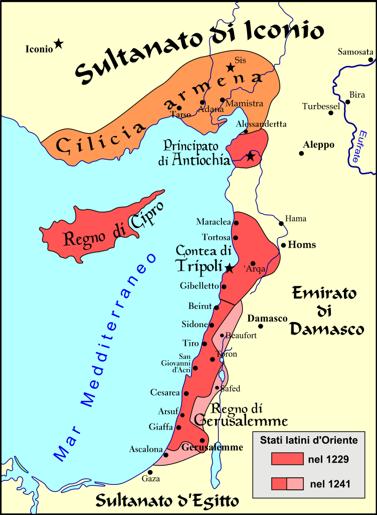
Français : Carte politique du Proche-Orient de 1229 à 1241 |
| Date | (UTC) |
| Source | |
| Author | |
| Other versions |
[]
See also[edit] |


| This is a retouched picture, which means that it has been digitally altered from its original version. Modifications: translated into italian language. The original can be viewed here: Map Crusader states 1240-fr.svg:
|
I, the copyright holder of this work, hereby publish it under the following licenses:
This file is licensed under the Creative Commons Attribution-Share Alike 3.0 Unported, 2.5 Generic, 2.0 Generic and 1.0 Generic license.
- You are free:
- to share – to copy, distribute and transmit the work
- to remix – to adapt the work
- Under the following conditions:
- attribution – You must give appropriate credit, provide a link to the license, and indicate if changes were made. You may do so in any reasonable manner, but not in any way that suggests the licensor endorses you or your use.
- share alike – If you remix, transform, or build upon the material, you must distribute your contributions under the same or compatible license as the original.

|
Permission is granted to copy, distribute and/or modify this document under the terms of the GNU Free Documentation License, Version 1.2 or any later version published by the Free Software Foundation; with no Invariant Sections, no Front-Cover Texts, and no Back-Cover Texts. A copy of the license is included in the section entitled GNU Free Documentation License. |
You may select the license of your choice.
Original upload log[edit]
This image is a derivative work of the following images:
- File:Levant_1240-fr.svg licensed with Cc-by-sa-3.0,2.5,2.0,1.0, GFDL
- 2008-08-22T19:57:36Z Odejea 507x690 (651375 Bytes) == Description == {{Information |Description={{en|1=A political map of the [[w:en:Near East]] from 1229 until 1241 [[w:en:Common Era|CE]].}} {{fr|1=Carte politique du [[w:fr:Proche-Orient|Proche-Orient]] de 1229 à 1241 }} |S
Uploaded with derivativeFX
File history
Click on a date/time to view the file as it appeared at that time.
| Date/Time | Thumbnail | Dimensions | User | Comment | |
|---|---|---|---|---|---|
| current | 15:00, 12 July 2009 | | 507 × 690 (699 KB) | Franco aq (talk | contribs) | {{Information |Description={{it|1=Carta politica del Vicino Oriente dal 1229 al 1241 e.v. }} {{en|1=A political map of the Near East from 1229 until 1241 CE.}} {{fr|1=Car |
You cannot overwrite this file.
File usage on Commons
The following 8 pages use this file:
- File:Levante 1240-it.svg (file redirect)
- File:Map Crusader states 1240-de.svg
- File:Map Crusader states 1240-eng.png
- File:Map Crusader states 1240-fr.svg
- File:Map Crusader states 1240-fr2.svg
- File:Map Crusader states 1240-it.svg
- File:Map Crusader states 1240-pt.svg
- Template:Other versions/Map Crusader states 1240
File usage on other wikis
The following other wikis use this file:
- Usage on it.wikipedia.org