File:Les Dirouilles map by Angus Faed 1940.jpg
Jump to navigation
Jump to search

Size of this preview: 800 × 571 pixels. Other resolutions: 320 × 228 pixels | 640 × 457 pixels | 1,024 × 731 pixels | 1,280 × 913 pixels | 2,560 × 1,827 pixels | 4,000 × 2,854 pixels.
Original file (4,000 × 2,854 pixels, file size: 8.33 MB, MIME type: image/jpeg)
Captions
Captions
Add a one-line explanation of what this file represents
Summary[edit]
| Description |
Deutsch: handgezeichnete Karte der Les Dirouilles nördlich von Jersey, Kanalinseln
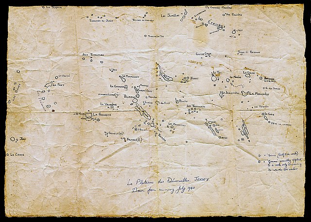
English: hand-drawn map of Les Dirouilles north of Jersey, Channel Islands. The map was created from memory after the author took the last boat from Jersey to England before the German occupation. He wanted to preserve the names of the rocks, much of which had been passed by oral tradition, and hoped that the maps would be useful in a British attempt to recapture Jersey from foreign occupation. |
| Date | |
| Source | https://www.theislandwiki.org/index.php/Le_Plateau_des_Derouilles |
| Author | Angus Faed (*January 1911 on Jersey, †May 1987 on Jersey) |
| Permission (Reusing this file) |
|
| Other versions |
|

Licensing[edit]
This file is licensed under the Creative Commons Attribution-Share Alike 4.0 International license.
- You are free:
- to share – to copy, distribute and transmit the work
- to remix – to adapt the work
- Under the following conditions:
- attribution – You must give appropriate credit, provide a link to the license, and indicate if changes were made. You may do so in any reasonable manner, but not in any way that suggests the licensor endorses you or your use.
- share alike – If you remix, transform, or build upon the material, you must distribute your contributions under the same or compatible license as the original.
File history
Click on a date/time to view the file as it appeared at that time.
| Date/Time | Thumbnail | Dimensions | User | Comment | |
|---|---|---|---|---|---|
| current | 09:03, 12 March 2022 | | 4,000 × 2,854 (8.33 MB) | Ratzer (talk | contribs) | Uploaded a work by Angus Faedd from http://www.theislandwiki.org/index.http://www.theislandwiki.org/index.php/Le_Plateau_des_Derouillesphp/Le_Plateau_des_Derouilles with UploadWizard |
You cannot overwrite this file.
File usage on Commons
The following page uses this file:
File usage on other wikis
The following other wikis use this file:
- Usage on de.wikipedia.org
- Usage on en.wikipedia.org
- Usage on vi.wikipedia.org