File:Leeds inner ring road - geograph.org.uk - 715778.jpg
Jump to navigation
Jump to search
No higher resolution available.
Leeds_inner_ring_road_-_geograph.org.uk_-_715778.jpg (640 × 424 pixels, file size: 84 KB, MIME type: image/jpeg)
Captions
Captions
Add a one-line explanation of what this file represents
Summary[edit]
| Description |
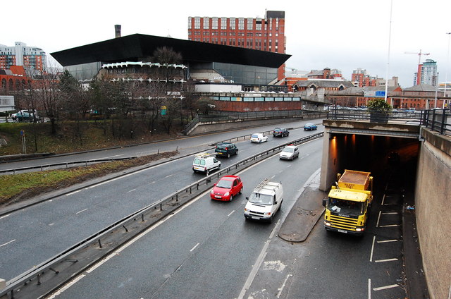
English: Leeds inner ring road During the early 1970's, Leeds was clearing huge areas of older housing, to improve the city's ever growing traffic congestion. The Leeds inner ring, was a mixture of open & tunnel sections. Opened in 1974, Leeds was to use the motto 'Leeds motorway city of the 1970's' This view shows the Leeds International pool, Built in 1967 it is at the time of writing (March 6th 2008)only months away from demolition. The International pool has always been a controversial building, The Architect John Poulson was to even cause a major political scandal, and was subsequently jailed for corruption.
To see more behind the scenes views, taken only weeks before demolition, with the Poulson story and detailed history of the building see here http://blog.myspace.com/index.cfm?fuseaction=blog.view&friendID=265602590&blogID=361721416 |
| Date | |
| Source | From geograph.org.uk |
| Author | philld |
| Attribution (required by the license) | philld / Leeds inner ring road / |
| Object location | | View this and other nearby images on: OpenStreetMap |
|---|
_&language=en)
Licensing[edit]

|
This image was taken from the Geograph project collection. See this photograph's page on the Geograph website for the photographer's contact details. The copyright on this image is owned by philld and is licensed for reuse under the Creative Commons Attribution-ShareAlike 2.0 license.
|
This file is licensed under the Creative Commons Attribution-Share Alike 2.0 Generic license.
Attribution: philld
- You are free:
- to share – to copy, distribute and transmit the work
- to remix – to adapt the work
- Under the following conditions:
- attribution – You must give appropriate credit, provide a link to the license, and indicate if changes were made. You may do so in any reasonable manner, but not in any way that suggests the licensor endorses you or your use.
- share alike – If you remix, transform, or build upon the material, you must distribute your contributions under the same or compatible license as the original.
File history
Click on a date/time to view the file as it appeared at that time.
| Date/Time | Thumbnail | Dimensions | User | Comment | |
|---|---|---|---|---|---|
| current | 01:42, 19 February 2011 | | 640 × 424 (84 KB) | GeographBot (talk | contribs) | == {{int:filedesc}} == {{Information |description={{en|1=Leeds inner ring road During the early 1970's, Leeds was clearing huge areas of older housing, to improve the city's ever growing traffic congestion. The Leeds inner ring, was a mixture of open & tu |
You cannot overwrite this file.
File usage on Commons
There are no pages that use this file.