File:Le traict du Croisic.svg
Jump to navigation
Jump to search

Size of this PNG preview of this SVG file: 800 × 469 pixels. Other resolutions: 320 × 188 pixels | 640 × 376 pixels | 1,024 × 601 pixels | 1,280 × 751 pixels | 2,560 × 1,502 pixels | 1,498 × 879 pixels.
Original file (SVG file, nominally 1,498 × 879 pixels, file size: 326 KB)
Captions
Captions
Add a one-line explanation of what this file represents
| Description |
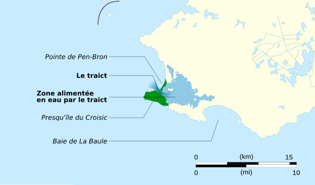
English: map for explanation of the traict in Le Croisic Français : Carte expliquant le passage du traict, entre la presqu'île du Croisic et la pointe de Pen-Bron. |
| Date | (UTC) |
| Source | |
| Author |
|
| This is a retouched picture, which means that it has been digitally altered from its original version. Modifications: découpe et ajout des informations sur le traict du Croisic. The original can be viewed here: Loire-Atlantique department relief location map.jpg:
|
This W3C-unspecified vector image was created with Inkscape .
I, the copyright holder of this work, hereby publish it under the following licenses:
This file is licensed under the Creative Commons Attribution-Share Alike 3.0 Unported license.
- You are free:
- to share – to copy, distribute and transmit the work
- to remix – to adapt the work
- Under the following conditions:
- attribution – You must give appropriate credit, provide a link to the license, and indicate if changes were made. You may do so in any reasonable manner, but not in any way that suggests the licensor endorses you or your use.
- share alike – If you remix, transform, or build upon the material, you must distribute your contributions under the same or compatible license as the original.

|
Permission is granted to copy, distribute and/or modify this document under the terms of the GNU Free Documentation License, Version 1.2 or any later version published by the Free Software Foundation; with no Invariant Sections, no Front-Cover Texts, and no Back-Cover Texts. A copy of the license is included in the section entitled GNU Free Documentation License. |
You may select the license of your choice.
Original upload log[edit]
This image is a derivative work of the following images:
- File:Loire-Atlantique_department_relief_location_map.jpg licensed with Cc-by-sa-3.0, GFDL
- 2010-07-18T13:40:16Z Sting 1101x984 (258826 Bytes) Color profile
- 2008-08-12T21:53:56Z Sting 1101x984 (250279 Bytes) == Summary == {{Location|47|21|00|N|01|45|00|W|scale:1000000}} {{Information |Description={{en|Blank physical map of the department of [[:en:Loire-Atlantique|Loire-Atlantique]], France, for geo-location purpose, with distinc
Uploaded with derivativeFX
File history
Click on a date/time to view the file as it appeared at that time.
| Date/Time | Thumbnail | Dimensions | User | Comment | |
|---|---|---|---|---|---|
| current | 13:52, 9 June 2011 | | 1,498 × 879 (326 KB) | Cj73 (talk | contribs) | Amélioration du rendu de la police de caractère dans la miniature |
| 16:50, 21 November 2010 |  | 1,498 × 879 (258 KB) | Cj73 (talk | contribs) | Diverses améliorations de la carte (couleur, typo, résolution...) | |
| 00:08, 5 November 2010 |  | 524 × 372 (17 KB) | Hellotheworld (talk | contribs) | ajout d'une échelle (4km) + "correction" de la carte sur une zone EMERGEE | |
| 23:59, 4 November 2010 |  | 524 × 372 (17 KB) | Hellotheworld (talk | contribs) | {{Information |Description={{en|map for explanation of the traict in Le Croisic}} {{fr|Carte expliquant le passage du traict, entre la presqu'île du Croisic et la pointe de Pen-Bron.}}<br/> |Source=*[[:File:Loire-Atlantique_department_relief_location_ma |
You cannot overwrite this file.
File usage on Commons
There are no pages that use this file.
File usage on other wikis
The following other wikis use this file:
- Usage on eo.wikipedia.org
- Usage on fr.wikipedia.org