File:Lavoir marbehan.PNG

Original file (938 × 268 pixels, file size: 619 KB, MIME type: image/png)
Captions
Captions
Summary
[edit]
| Description |
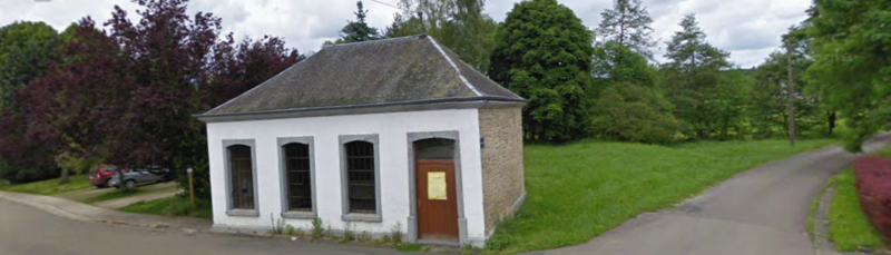
Français : Cette fontaine a vu sa construction terminée en 1896. Élevé dans le bas du village de Marbehan juste à côté de la rivière la Mellier.
Faites en moellons nu ou sous cimentage ; calcaire gris, nu ou peint. Érigé sur le modèle similaire que celui de Rulles. Trois fenêtres et porte en façade, deux fenêtres à l’arrière. Linteaux échancrés. Bâtière à croupes, ardoises. Corniche calcaire en doucine sur cavet. Le lavoir devient une maison de village destinée à tous les habitants de Marbehan. Le local et son équipement peuvent accueillir des activités d’animations et de rencontres jusqu’à 25 personnes : repas et rencontres de familles, réunions diverses, expositions, activités pédagogiques et touristiques,… Monument classé par la Région wallonne depuis le 6 janvier 1983.
|
||
| Date | |||
| Source | Own work | ||
| Author | Meg0196 |
| Object location | | View this and other nearby images on: OpenStreetMap |
|---|
Licensing
[edit]
- You are free:
- to share – to copy, distribute and transmit the work
- to remix – to adapt the work
- Under the following conditions:
- attribution – You must give appropriate credit, provide a link to the license, and indicate if changes were made. You may do so in any reasonable manner, but not in any way that suggests the licensor endorses you or your use.
- share alike – If you remix, transform, or build upon the material, you must distribute your contributions under the same or compatible license as the original.

|
This image was uploaded as part of Wiki Loves Monuments 2012.
|
 |
File history
Click on a date/time to view the file as it appeared at that time.
| Date/Time | Thumbnail | Dimensions | User | Comment | |
|---|---|---|---|---|---|
| current | 13:45, 22 September 2012 | 938 × 268 (619 KB) | Meg0196 (talk | contribs) | User created page with UploadWizard |
You cannot overwrite this file.
File usage on Commons
The following page uses this file:
File usage on other wikis
The following other wikis use this file:
- Usage on en.wikipedia.org
- Usage on fr.wikipedia.org
- Usage on nl.wikipedia.org