File:Lava Flows and Calcareous Sediments near Mayrouba in Lebanon.jpg
Jump to navigation
Jump to search
No higher resolution available.
Lava_Flows_and_Calcareous_Sediments_near_Mayrouba_in_Lebanon.jpg (800 × 529 pixels, file size: 535 KB, MIME type: image/jpeg)
Captions
Captions
Add a one-line explanation of what this file represents
Summary[edit]
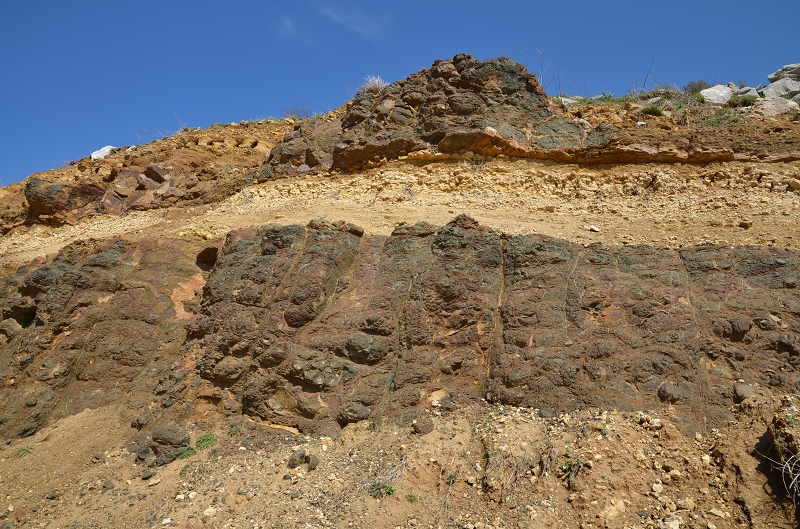
| Description | Cliff with lava flows of dark-coloured basalt interlayered with light-coloured calcareous marl sediments at the Jurassic-Cretaceous stratigraphic boundary, near Mayrouba in Lebanon. The lava flows show spheroidal weathering. |
| Date | |
| Source | http://www.geodiversite.net/media1197 |
| Author | laurence comte http://www.geodiversite.net/auteur131 |
| Camera location | | View this and other nearby images on: OpenStreetMap |
|---|
Licensing[edit]
This file is licensed under the Creative Commons Attribution-Share Alike 3.0 Unported license.
- You are free:
- to share – to copy, distribute and transmit the work
- to remix – to adapt the work
- Under the following conditions:
- attribution – You must give appropriate credit, provide a link to the license, and indicate if changes were made. You may do so in any reasonable manner, but not in any way that suggests the licensor endorses you or your use.
- share alike – If you remix, transform, or build upon the material, you must distribute your contributions under the same or compatible license as the original.
This file, which was originally posted to
geodiversite.net, was reviewed on 18 January 2015 by reviewer Bobamnertiopsis, who confirmed that it was available there under the stated license on that date.
|
File history
Click on a date/time to view the file as it appeared at that time.
| Date/Time | Thumbnail | Dimensions | User | Comment | |
|---|---|---|---|---|---|
| current | 18:41, 18 January 2015 | | 800 × 529 (535 KB) | GeoWriter (talk | contribs) | User created page with UploadWizard |
You cannot overwrite this file.
File usage on Commons
There are no pages that use this file.
File usage on other wikis
The following other wikis use this file: