File:Landkarte Peipussee.PNG
Jump to navigation
Jump to search
No higher resolution available.
Landkarte_Peipussee.PNG (327 × 351 pixels, file size: 15 KB, MIME type: image/png)
Captions
Captions
Add a one-line explanation of what this file represents
Summary[edit]
| Description |
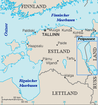
English: Map of Lake Peipus
Čeština: Mapa čudského jezera
Deutsch: Landkarte des Peipussees |
| Date | 29 December 2004 (original upload date) |
| Source | Originally from the CIA World Factbook. Taken from http://www.lib.utexas.edu/maps/cia04/estonia_sm04.gif; modified by Sascha Brück. |
| Author | CIA |
Licensing[edit]
This image is in the public domain because it contains materials that originally came from the United States Central Intelligence Agency's World Factbook.
|
 |
Original upload log[edit]
Transferred from de.wikipedia to Commons by sevela.p.
The original description page was here. All following user names refer to de.wikipedia.
- 2004-12-29 01:11 Sascha Brück 327×351×8 (15518 bytes) GFDL
File history
Click on a date/time to view the file as it appeared at that time.
| Date/Time | Thumbnail | Dimensions | User | Comment | |
|---|---|---|---|---|---|
| current | 16:12, 23 March 2008 | | 327 × 351 (15 KB) | File Upload Bot (Magnus Manske) (talk | contribs) | {{BotMoveToCommons|de.wikipedia}} {{Information |Description={{de|'''Bearbeitet:''' Sascha Brück}} |Source=Transferred from [http://de.wikipedia.org de.wikipedia]; Transfer was stated to be made by User:sevela.p.<br/> (Original text : ''[http://www. |
You cannot overwrite this file.
File usage on Commons
There are no pages that use this file.
File usage on other wikis
The following other wikis use this file:
- Usage on cs.wikipedia.org
- Usage on da.wikipedia.org