File:Lake Titicaca Modis Sensor Nov 4 2001.jpg
Jump to navigation
Jump to search

Size of this preview: 466 × 599 pixels. Other resolutions: 187 × 240 pixels | 373 × 480 pixels | 597 × 768 pixels | 796 × 1,024 pixels | 1,593 × 2,048 pixels | 2,800 × 3,600 pixels.
Original file (2,800 × 3,600 pixels, file size: 2.06 MB, MIME type: image/jpeg)
Captions
Captions
Add a one-line explanation of what this file represents
Summary[edit]
| Description |
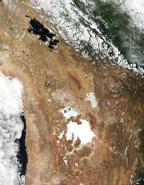
English: MODIS true-color image from November 4, 2001 showing the southern Altiplano including en:Lake Titicaca, the en:Salar de Uyuni, and the en:Salar de Coipasa. |
| Date | |
| Source |
http://visibleearth.nasa.gov/view_rec.php?id=2317
|
| Author | Jacques Descloitres, MODIS Land Rapid Response Team, NASA/GSFC |
Licensing[edit]
| This file is in the public domain in the United States because it was solely created by NASA. NASA copyright policy states that "NASA material is not protected by copyright unless noted". (See Template:PD-USGov, NASA copyright policy page or JPL Image Use Policy.) | ||
 |
Warnings:
|
Original upload log[edit]
The original description page was here. All following user names refer to en.wikipedia.
- 2007-09-20 23:17 Nathancraig 2800×3600×8 (2159740 bytes) MODIS true-color image from November 4, 2001 showing the southern Altiplano including Lake Titicaca, the Salar de Atacama and the Salar de Coipasa.
File history
Click on a date/time to view the file as it appeared at that time.
| Date/Time | Thumbnail | Dimensions | User | Comment | |
|---|---|---|---|---|---|
| current | 18:13, 12 January 2008 | | 2,800 × 3,600 (2.06 MB) | File Upload Bot (Magnus Manske) (talk | contribs) | {{BotMoveToCommons|en.wikipedia}} {{Information |Description={{en|MODIS true-color image from November 4, 2001 showing the southern Altiplano including en:Lake Titicaca, the en:Salar de Atacama, the en:Salar de Uyuni, and the [[:en:Salar d |
You cannot overwrite this file.
File usage on Commons
The following page uses this file:
File usage on other wikis
The following other wikis use this file:
- Usage on be.wikipedia.org
- Usage on cs.wikipedia.org
- Usage on en.wikipedia.org
- Usage on es.wikipedia.org
- Usage on fr.wikipedia.org
- Usage on gl.wikipedia.org
- Usage on he.wikipedia.org
- Usage on hu.wikipedia.org
- Usage on it.wikipedia.org
- Usage on nn.wikipedia.org
- Usage on pt.wikipedia.org
- Usage on ru.wikipedia.org
- Usage on simple.wikipedia.org
- Usage on uk.wikipedia.org