File:Lake Shasta Levels 2015-2016 NWS.jpg
Jump to navigation
Jump to search

Size of this preview: 495 × 600 pixels. Other resolutions: 198 × 240 pixels | 600 × 727 pixels.
Original file (600 × 727 pixels, file size: 67 KB, MIME type: image/jpeg)
Captions
Captions
Add a one-line explanation of what this file represents
| Description |
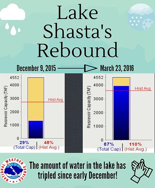
English: Due to El Nino storms during the winter of 2015-2016, Lake Shasta has risen 134 feet/40.8 meters since early December, 2015. |
|||
| Date | ||||
| Source | https://twitter.com/NWSMedford https://pbs.twimg.com/media/CeVHkErUYAI9ge6.jpg:large | |||
| Author | National Weather Service | |||
| Permission (Reusing this file) |
|
| Object location | | View this and other nearby images on: OpenStreetMap |
|---|
File history
Click on a date/time to view the file as it appeared at that time.
| Date/Time | Thumbnail | Dimensions | User | Comment | |
|---|---|---|---|---|---|
| current | 15:10, 25 March 2016 | | 600 × 727 (67 KB) | Ellin Beltz (talk | contribs) | {{Information |Description ={{en|1=Due to El Nino storms during the winter of 2015-2016, Lake Shasta has risen 134 feet/40.8 meters since early December, 2015.}} |Source =https://twitter.com/NWSMedford https://pbs.twimg.com/media/CeVHkErUYAI... |
You cannot overwrite this file.
File usage on Commons
There are no pages that use this file.