File:Laizhou Bay, China ESA23271000.jpeg

Original file (19,600 × 14,192 pixels, file size: 10.91 MB, MIME type: image/jpeg)
Captions
Captions
Summary
[edit]| Warning | The original file is very high-resolution. It might not load properly or could cause your browser to freeze when opened at full size. |
|---|
| Description |
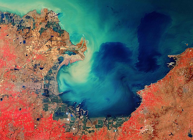
English: The Copernicus Sentinel-2 mission takes us over the sediment-stained waters in Laizhou Bay, located on the southern shores of the Bohai Sea, on the east coast of mainland China. Zoom in to see this image at its full 10 m resolution or click on the circles to learn more about the features in it. The bay is the smallest of three main bays of the Bohai Sea, and is named after the city of Laizhou, visible to the east. Large quantities of sediment carried by the Yellow River, visible in the left of the image, discolour the waters of the bay and appear turquoise. This sediment can be seen throughout the waters in this image, even far from the coast. The Yellow River is China’s second longest river, with a length of over 5400 km, and is surpassed only by the Yangtze River. The river rises in the Bayan Har Mountains in Western China and flows through nine provinces before emptying into the Laizhou Bay. Its drainage basin is the third largest in the country, with an area of around 750 000 sq km. The river is estimated to carry 1.6 billion tonnes of silt annually, carrying the majority to the sea. Owing to this heavy load of silt, the Yellow River deposits soil in stretches, ultimately elevating the river bed. Excessive sediment deposits have raised the river bed several metres above the surrounding ground, sometimes causing damaging floods. On the southern coast of Laizhou Bay, in the bottom of the image, flooded fields are visible and are most likely artificial fish farms. The city of Dongying, home to the second largest oilfield in China, is visible in the left of the image. This image was processed in a way that included the near-infrared channel, which makes vegetation appear bright red. The lush vegetation can be distinguished from the brown fields in the image, which are unharvested or not yet fully grown. Copernicus Sentinel-2 is a two-satellite mission. Each satellite carries a high-resolution camera that images Earth’s surface in 13 spectral bands. The mission is mostly used to track changes in the way land is being used and to monitor the health of vegetation. This image, acquired on 26 February 2020, is also featured on the Earth from Space video programme. |
| Date | 23 April 2021 (upload date) |
| Source | Laizhou Bay, China |
| Author | European Space Agency |
| Other versions |
|
| Activity | Observing the Earth |
| Mission | Sentinel-2 |
| Set | Earth observation image of the week |
| System | Copernicus |

Licensing
[edit]

|
This image contains data from a satellite in the Copernicus Programme, such as Sentinel-1, Sentinel-2 or Sentinel-3. Attribution is required when using this image.
Attribution: Contains modified Copernicus Sentinel data 2020
The use of Copernicus Sentinel Data is regulated under EU law (Commission Delegated Regulation (EU) No 1159/2013 and Regulation (EU) No 377/2014). Relevant excerpts:
Free access shall be given to GMES dedicated data [...] made available through GMES dissemination platforms [...].
Access to GMES dedicated data [...] shall be given for the purpose of the following use in so far as it is lawful:
GMES dedicated data [...] may be used worldwide without limitations in time.
GMES dedicated data and GMES service information are provided to users without any express or implied warranty, including as regards quality and suitability for any purpose. |
This media was created by the European Space Agency (ESA).
Where expressly so stated, images or videos are covered by the Creative Commons Attribution-ShareAlike 3.0 IGO (CC BY-SA 3.0 IGO) licence, ESA being an Intergovernmental Organisation (IGO), as defined by the CC BY-SA 3.0 IGO licence. The user is allowed under the terms and conditions of the CC BY-SA 3.0 IGO license to Reproduce, Distribute and Publicly Perform the ESA images and videos released under CC BY-SA 3.0 IGO licence and the Adaptations thereof, without further explicit permission being necessary, for as long as the user complies with the conditions and restrictions set forth in the CC BY-SA 3.0 IGO licence, these including that:
See the ESA Creative Commons copyright notice for complete information, and this article for additional details.
|
 | |
This file is licensed under the Creative Commons Attribution-ShareAlike 3.0 IGO license. Attribution: ESA, CC BY-SA IGO 3.0
| ||
File history
Click on a date/time to view the file as it appeared at that time.
| Date/Time | Thumbnail | Dimensions | User | Comment | |
|---|---|---|---|---|---|
| current | 10:27, 23 April 2021 | | 19,600 × 14,192 (10.91 MB) | OptimusPrimeBot (talk | contribs) | #Spacemedia - Upload of https://www.esa.int/var/esa/storage/images/esa_multimedia/images/2021/04/laizhou_bay_china/23270990-1-eng-GB/Laizhou_Bay_China.jpg via Commons:Spacemedia |
You cannot overwrite this file.
File usage on Commons
The following page uses this file:
File usage on other wikis
The following other wikis use this file:
- Usage on zh.wikipedia.org