File:Laguna del Maule - NASA Earth Observatory.jpg

Original file (1,281 × 1,218 pixels, file size: 524 KB, MIME type: image/jpeg)
Captions
Captions
Summary[edit]
| Description |
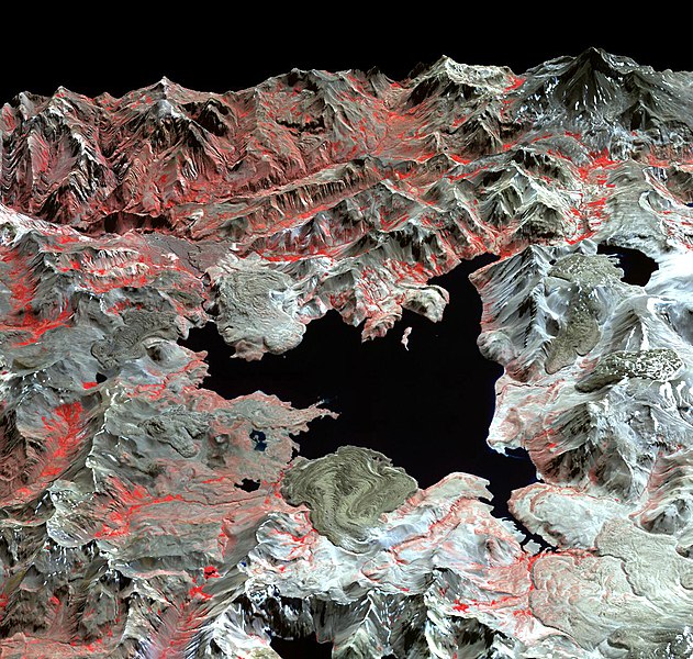
To download the full resolution and other files go to: earthobservatory.nasa.gov/IOTD/view.php?id=76827&src=... In the Andean mountain range, stretching across the border between Chile and Argentina, lies a volcanic caldera named Laguna del Maule, roughly 15 by 25 kilometers (9 by 15 miles) across. Within the northern part of the caldera lies Maule Lake, which is surrounded by a complex volcanic landscape. This perspective image is made from data acquired by the Advanced Spaceborne Thermal Emission and Reflection Radiometer (ASTER) on NASA’s Terra satellite on April 9, 2003. ASTER produces images using infrared, red, and green wavelengths of light. In this image, vegetated areas range in color from red to pink, snow is white, water is black, and bare rock is earth-toned. Laguna del Maule holds an assortment of volcanic features, including small stratovolcanoes, lava domes, and cinder cones. Some of the most prominent features surrounding Lake Maule are lava flows. Some of those lava flows protrude into the lake, looking a little like dough spreading under its own weight. Volcanologists estimate that volcanoes at this site have been active over the past 10,000 years, but the date of the last eruption at Laguna del Maule is unknown. NASA image courtesy of GSFC/METI/ERSDAC/JAROS, and the U.S./Japan ASTER Science Team. Caption by Michon Scott. The Earth Observatory's mission is to share with the public the images, stories, and discoveries about climate and the environment that emerge from NASA research, including its satellite missions, in-the-field research, and climate models. |
| Date | |
| Source | Laguna del Maule |
| Author | NASA's Earth Observatory |
| Camera location | | View this and other nearby images on: OpenStreetMap |
|---|
Licensing[edit]
- You are free:
- to share – to copy, distribute and transmit the work
- to remix – to adapt the work
- Under the following conditions:
- attribution – You must give appropriate credit, provide a link to the license, and indicate if changes were made. You may do so in any reasonable manner, but not in any way that suggests the licensor endorses you or your use.
| This image was originally posted to Flickr by NASA Earth Observatory at https://www.flickr.com/photos/68824346@N02/6628089879. It was reviewed on 2 July 2012 by FlickreviewR and was confirmed to be licensed under the terms of the cc-by-2.0. |
File history
Click on a date/time to view the file as it appeared at that time.
| Date/Time | Thumbnail | Dimensions | User | Comment | |
|---|---|---|---|---|---|
| current | 06:10, 15 September 2019 | | 1,281 × 1,218 (524 KB) | Juan Villalobos (talk | contribs) | full resolution |
| 17:15, 2 July 2012 |  | 720 × 480 (191 KB) | Dzlinker (talk | contribs) | == {{int:filedesc}} == {{Information |Description=To download the full resolution and other files go to: [http://earthobservatory.nasa.gov/IOTD/view.php?id=76827&src=flickr earthobservatory.nasa.gov/IOTD/view.php?id=76827&src=...] In the Andean mounta... |
You cannot overwrite this file.
File usage on Commons
The following 2 pages use this file:
.jpg&redirect=no)
File usage on other wikis
The following other wikis use this file:
- Usage on as.wikipedia.org
- Usage on en.wikipedia.org
- Laguna del Maule (volcano)
- Wikipedia:Today's featured article/June 2021
- User:Gog the Mild/Blurbs/Archive 1
- Wikipedia talk:Featured article candidates/Laguna del Maule (volcano)/archive2
- Wikipedia:Today's featured article/June 6, 2021
- Wikipedia:Main Page history/2021 June 6
- Wikipedia:Main Page history/2021 June 6b
- Usage on it.wikipedia.org
Metadata
- Laguna del Maule (volcano)
- Photos by ASTER
- Laguna del Maule
- False-color satellite images
- Satellite pictures of volcanoes in Chile
- Color-infrared satellite pictures
- Lava domes in Argentina
- Snowy landscapes in Argentina
- Volcanic landforms of Argentina
- Magmatism of Chile
- Satellite pictures of volcanoes in Chile in 2003
- Volcano monitoring in South America
- Lava deltas in lakes