File:La palma volcano-close.jpg
Jump to navigation
Jump to search

Size of this preview: 800 × 528 pixels. Other resolutions: 320 × 211 pixels | 640 × 423 pixels | 1,024 × 676 pixels | 1,280 × 845 pixels | 3,022 × 1,996 pixels.
Original file (3,022 × 1,996 pixels, file size: 922 KB, MIME type: image/jpeg)
Captions
Captions
Add a one-line explanation of what this file represents
Summary[edit]
| Description |
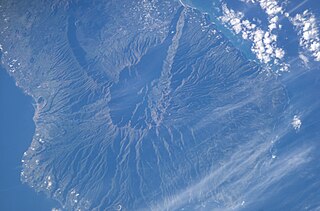
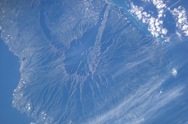
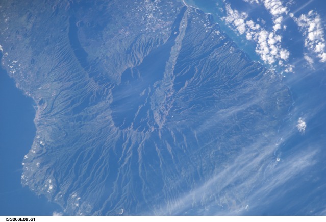
English: Satellite photo of Caldera de Taburiente and Cumbre Vieja, La Palma, Canary Islands. (South is above, North below.) Volcano, close up |
| Date | |
| Source | JSC Gateway to Astronaut Photography of Earth |
| Author | Earth Science and Remote Sensing Unit, Lyndon B. Johnson Space Center |
| Other versions |
http://eol.jsc.nasa.gov/DatabaseImages/ESC/small/ISS006/ISS006-E-9561.JPG |
| Mission | ISS006 |
| Roll | E |
| Frame | 9561 |
| Geographic area | the Canary Islands |
| Features | LA PALMA ISLAND, CENTRAL |
| Cloud percentage | 10% |
| Altitude | 211 nautical miles (391 km) |
| Look angle | 27° |
| Look direction | SE |
| Sun Azimuth | 133° |
| Sun Elevation | 19° |
| Camera | Kodak DCS760c Electronic Still Camera |
| Focal length | 400 mm |
| Object location | | View this and other nearby images on: OpenStreetMap |
|---|
| Camera location | | View this and other nearby images on: OpenStreetMap |
|---|
This image or video was catalogued by Johnson Space Center of the United States National Aeronautics and Space Administration (NASA) under Photo ID: ISS006-E-09561. This tag does not indicate the copyright status of the attached work. A normal copyright tag is still required. See Commons:Licensing. Other languages:
|
Licensing[edit]
| This file is in the public domain in the United States because it was solely created by NASA. NASA copyright policy states that "NASA material is not protected by copyright unless noted". (See Template:PD-USGov, NASA copyright policy page or JPL Image Use Policy.) | ||
 |
Warnings:
|
File history
Click on a date/time to view the file as it appeared at that time.
| Date/Time | Thumbnail | Dimensions | User | Comment | |
|---|---|---|---|---|---|
| current | 14:45, 7 March 2020 | | 3,022 × 1,996 (922 KB) | Lojwe (talk | contribs) | Cropped < 1 % horizontally, 3 % vertically using CropTool with precise mode. |
| 02:26, 13 October 2015 |  | 3,032 × 2,064 (943 KB) | Xb2u7Zjzc32 (talk | contribs) | ISS006-E-09561 3032 x 2064 pixels | |
| 09:39, 17 March 2008 |  | 639 × 422 (61 KB) | Mbdortmund (talk | contribs) | ||
| 05:15, 30 December 2004 |  | 639 × 435 (70 KB) | Clngre~commonswiki (talk | contribs) | Satellite photo of Cumbre Vieja, La Palma, Canary Islands. Volcano, close up {{PD-USGov-NASA}} |
You cannot overwrite this file.
File usage on Commons
The following 8 pages use this file:
File usage on other wikis
The following other wikis use this file:
- Usage on ca.wikipedia.org
- Usage on cs.wikipedia.org
- Usage on da.wikipedia.org
- Usage on de.wikipedia.org
- Usage on en.wikipedia.org
- Usage on es.wikipedia.org
- Usage on fr.wikipedia.org
- Usage on it.wikipedia.org
- Usage on ko.wikipedia.org
- Usage on nn.wikipedia.org
- Usage on no.wikipedia.org
- Usage on oc.wikipedia.org
- Usage on pt.wikipedia.org
- Usage on ru.wikipedia.org
- Usage on simple.wikipedia.org
- Usage on sk.wikipedia.org
- Usage on sl.wikipedia.org
- Usage on sv.wikipedia.org
- Usage on uk.wikipedia.org
- Usage on www.wikidata.org