File:L'île de la Réunion vue par le satellite Sentinel-2 (cropped).jpg

Original file (5,000 × 4,232 pixels, file size: 18.68 MB, MIME type: image/jpeg)
Captions
Captions
Summary[edit]
| Description |
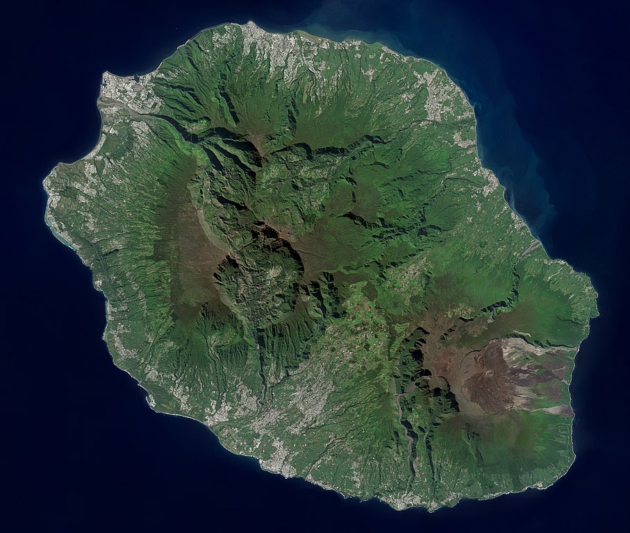
Français : L'île de la Réunion vue par le satellite Sentinel-2
English: Réunion island (Indian Ocean) photographed by Sentinel-2 satellite. |
| Date | |
| Source | https://phototheque.cnes.fr/cnes/media/68926 |
| Author | European Space Agency / CNES |
| Other versions |

.jpg&action=edit§ion=1)
| Camera location | | View this and other nearby images on: OpenStreetMap |
|---|
.jpg¶ms=-21.134472_N_0055.247103_E_globe:Earth_type:camera__&language=en)
Licensing[edit]
.jpg&action=edit§ion=2)

|
This image contains data from a satellite in the Copernicus Programme, such as Sentinel-1, Sentinel-2 or Sentinel-3. Attribution is required when using this image.
Attribution: Contains modified Copernicus Sentinel data 2021
The use of Copernicus Sentinel Data is regulated under EU law (Commission Delegated Regulation (EU) No 1159/2013 and Regulation (EU) No 377/2014). Relevant excerpts:
Free access shall be given to GMES dedicated data [...] made available through GMES dissemination platforms [...].
Access to GMES dedicated data [...] shall be given for the purpose of the following use in so far as it is lawful:
GMES dedicated data [...] may be used worldwide without limitations in time.
GMES dedicated data and GMES service information are provided to users without any express or implied warranty, including as regards quality and suitability for any purpose. |

|
This image has been assessed under the valued image criteria and is considered the most valued image on Commons within the scope: Réunion island, France - satellite view.. You can see its nomination here. |
.jpg)
File history
Click on a date/time to view the file as it appeared at that time.
| Date/Time | Thumbnail | Dimensions | User | Comment | |
|---|---|---|---|---|---|
| current | 14:12, 6 September 2022 | | 5,000 × 4,232 (18.68 MB) | Skimel (talk | contribs) | File:L'île de la Réunion vue par le satellite Sentinel-2.jpg cropped 15 % vertically using CropTool with precise mode. |
You cannot overwrite this file.
File usage on Commons
The following 87 pages use this file:
- Réunion
- User:Skimel/Contributions
- User talk:Skimel
- Commons:Valued image candidates/L'île de la Réunion vue par le satellite Sentinel-2 (cropped).jpg
- Commons:Valued images by topic/Places/Natural/Islands and shore sites
- File:L'île de la Réunion vue par le satellite Sentinel-2.jpg
- Category:1993 in Réunion
- Category:1998 in Réunion
- Category:2000 in Réunion
- Category:2002 in Réunion
- Category:2004 in Réunion
- Category:2007 in Réunion
- Category:2009 in Réunion
- Category:2010 in Réunion
- Category:2011 in Réunion
- Category:2012 in Réunion
- Category:2013 in Réunion
- Category:2014 in Réunion
- Category:2015 in Réunion
- Category:2016 in Réunion
- Category:2017 in Réunion
- Category:2018 in Réunion
- Category:2019 in Réunion
- Category:2020 in Réunion
- Category:Airports in Réunion
- Category:Animals of Réunion
- Category:Arrondissements of Réunion
- Category:Association football venues in Réunion
- Category:Births in Réunion
- Category:Bodies of water in Réunion
- Category:Bridges in Réunion
- Category:Capes of Réunion
- Category:Cemeteries in Réunion
- Category:Churches in Réunion
- Category:Communautés d'agglomération in Réunion
- Category:Companies of Réunion
- Category:Deaths in Réunion
- Category:Disasters and accidents in Réunion
- Category:Education in Réunion
- Category:Environmental problems in Réunion
- Category:Events in Réunion
- Category:Factory chimneys in Réunion
- Category:Festivals of Réunion
- Category:Fish of Réunion
- Category:Floods in Réunion
- Category:Forestry in Réunion
- Category:Groups of communes in Réunion
- Category:Infrastructure in Réunion
- Category:Landforms of Réunion
- Category:Maps of Réunion
- Category:Mosques in Réunion
- Category:Mountain passes of Réunion
- Category:Muslims from Réunion
- Category:People of Réunion
- Category:Pontederia crassipes in Réunion
- Category:Populated places in Réunion
- Category:Power plants in Réunion
- Category:Protected areas of Réunion
- Category:Rail transport in Réunion
- Category:Rivers of Réunion
- Category:Road bridges in Réunion
- Category:Roads in Réunion
- Category:Réunion
- Category:Réunion by century
- Category:Réunion by year
- Category:Réunion in the 1840s
- Category:Réunion in the 1950s
- Category:Réunion in the 1970s
- Category:Réunion in the 1980s
- Category:Réunion in the 1990s
- Category:Réunion in the 19th century
- Category:Réunion in the 2000s
- Category:Réunion in the 2010s
- Category:Réunion in the 2020s
- Category:Réunion in the 20th century
- Category:Réunion in the 21st century
- Category:Stadiums in Réunion
- Category:Templates related to Réunion
- Category:Town halls in Réunion
- Category:Trails in Réunion
- Category:Transport infrastructure in Réunion
- Category:Tunnels in Réunion
- Category:Volcanoes in Réunion
- Category:Water transport in Réunion
- Category:Waterfalls in Réunion
- Category:Wetlands of Réunion
- Category:Whale watching in Réunion
File usage on other wikis
The following other wikis use this file:
- Usage on ar.wikipedia.org
- Usage on arz.wikipedia.org
- Usage on ast.wikipedia.org
- Usage on az.wikipedia.org
- Usage on ca.wikipedia.org
- Usage on ce.wikipedia.org
- Usage on cy.wikipedia.org
- Usage on diq.wikipedia.org
- Usage on es.wikipedia.org
- Usage on es.wikivoyage.org
- Usage on fr.wikinews.org
- Usage on fr.wikivoyage.org
- Usage on ga.wikipedia.org
- Usage on gl.wikipedia.org
- Usage on ht.wikipedia.org
- Usage on hy.wikipedia.org
- Usage on ia.wikipedia.org
- Usage on ig.wikipedia.org
- Usage on ku.wikipedia.org
- Usage on no.wikipedia.org
- Usage on oc.wikipedia.org
- Usage on pl.wikipedia.org
- Usage on ps.wikipedia.org
- Usage on tl.wikipedia.org
- Usage on vec.wikipedia.org
- Usage on vi.wikipedia.org
- Usage on www.wikidata.org
.jpg&oldid=769175752)