File:Kurdish-inhabited areas (orthographic projection with inset).svg
Jump to navigation
Jump to search

Size of this PNG preview of this SVG file: 512 × 512 pixels. Other resolutions: 240 × 240 pixels | 480 × 480 pixels | 768 × 768 pixels | 1,024 × 1,024 pixels | 2,048 × 2,048 pixels.
Original file (SVG file, nominally 512 × 512 pixels, file size: 852 KB)
Captions
Captions
Add a one-line explanation of what this file represents
Summary[edit]
| Description |
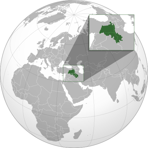
English: Kurdish-inhabited areas (according to the CIA, 1992).[1]
(Green) Kurdistan. #CCCED1 (Light-gray)
This map is uses an orthographic projection and follows the following standards: |
| Date | |
| Source |
Own work using: |
| Author | Isochrone |
| Other versions |
|
| SVG development |
_box_inset_removed.jpg)
.svg&action=edit§ion=1)
-en.svg)
Licensing[edit]
.svg&action=edit§ion=2)
This file is licensed under the Creative Commons Attribution-Share Alike 4.0 International license.
- You are free:
- to share – to copy, distribute and transmit the work
- to remix – to adapt the work
- Under the following conditions:
- attribution – You must give appropriate credit, provide a link to the license, and indicate if changes were made. You may do so in any reasonable manner, but not in any way that suggests the licensor endorses you or your use.
- share alike – If you remix, transform, or build upon the material, you must distribute your contributions under the same or compatible license as the original.
References[edit]
.svg&action=edit§ion=3)
- ↑ The Kurdish lands.. Library of Congress. Retrieved on 6 November 2019.
File history
Click on a date/time to view the file as it appeared at that time.
| Date/Time | Thumbnail | Dimensions | User | Comment | |
|---|---|---|---|---|---|
| current | 03:25, 11 November 2023 | | 512 × 512 (852 KB) | Treetoes023 (talk | contribs) | Making border overlap easier to see. |
| 17:24, 28 September 2023 |  | 512 × 512 (852 KB) | Golden (talk | contribs) | restoring previous edit but with the shading | |
| 02:15, 28 September 2023 |  | 512 × 512 (794 KB) | Treetoes023 (talk | contribs) | Reverted to version as of 19:21, 13 June 2023 (UTC): Restoring shading. | |
| 20:09, 1 September 2023 |  | 512 × 512 (885 KB) | Golden (talk | contribs) | rmv de facto countries with zero recognition (Somaliland, NKR) | |
| 19:21, 13 June 2023 |  | 512 × 512 (794 KB) | Isochrone (talk | contribs) | oops | |
| 19:17, 13 June 2023 |  | 512 × 512 (793 KB) | Isochrone (talk | contribs) | change per request | |
| 16:45, 5 June 2023 |  | 512 × 512 (836 KB) | Isochrone (talk | contribs) | Uploaded a work by {{u|Isochrone}} from {{own using}} * 1992 CIA map with UploadWizard |
You cannot overwrite this file.
File usage on Commons
The following 6 pages use this file:
- User:Magog the Ogre/Multilingual legend/2023 June 1-10
- User:Magog the Ogre/Multilingual legend/2023 June 11-20
- User:Magog the Ogre/Multilingual legend/2023 November 11-15
- User:Magog the Ogre/Multilingual legend/2023 September 1-5
- User:Magog the Ogre/Multilingual legend/2023 September 26-30
- File:Kurdish-inhabited areas (orthographic projection).svg (file redirect)
.svg&redirect=no)
File usage on other wikis
The following other wikis use this file:
- Usage on ckb.wikipedia.org
- Usage on en.wikipedia.org
- Usage on got.wikipedia.org
- Usage on incubator.wikimedia.org
- Usage on ka.wikipedia.org
- Usage on lt.wikipedia.org
- Usage on mr.wikipedia.org
- Usage on ne.wikipedia.org
- Usage on pl.wikipedia.org
- Usage on qu.wikipedia.org
- Usage on ru.wikipedia.org
- Usage on simple.wikipedia.org
.svg&oldid=821040877)