File:Kriegskurve.jpg

Original file (1,182 × 1,379 pixels, file size: 208 KB, MIME type: image/jpeg)
Captions
Captions
| Description |
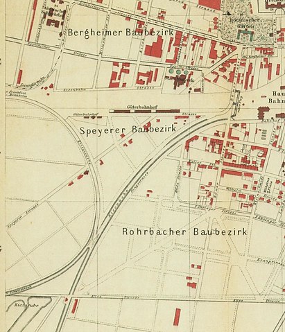
Deutsch: Karte des „Speyerer Baubezirk“ in Heidelberg Ende des 19. Jahrhunderts. Unter anderem ist die „Kriegskurve“ zu sehen, die 1864 erbaut wurde damit nicht alle Züge durch den Kopfbahnhof fahren müssen; Sie wurde 1910 bei den Vorbereitungen für den Umbau des Hauptbahnhofs abgerissen. Die Straße östlich der Kriegskurve wurde anfangs als Speyrer Straße bezeichnet, 1904 jedoch umbenannt in „Belfortstraße“. Die Kleine Speyrer Straße zwischen Belfortstraße unf Ringstraße wurde ab 1904 als „Kaiserstraße“ bezeichnet, der Güterweg westlich davon als „Wörthstraße“.[1] |
||||
| Date | before 1897 | ||||
| Source | Übersichts-Plan der Stadt Heidelberg und Umgebung. Officiell angefertigt durch das Tiefbauamt. Maßstab 1:7500. Beilage zu Karl Pfaff, Heidelberg und Umgebung, Heidelberg 1897. Via http://www.s197410804.online.de/ABC/ABCBahnhoefe.htm | ||||
| Author | Unknown author | ||||
| Permission (Reusing this file) |
|
||||
File history
Click on a date/time to view the file as it appeared at that time.
| Date/Time | Thumbnail | Dimensions | User | Comment | |
|---|---|---|---|---|---|
| current | 10:42, 19 January 2018 | | 1,182 × 1,379 (208 KB) | Nenntmichruhigip (talk | contribs) | {{Information |Description={{de|1=Karte des „Speyerer Baubezirk“ in Heidelberg Ende des 19. Jahrhunderts. Unter anderem ist die „Kriegskurve“ zu sehen, die 1864 erbaut wurde damit nicht alle Züge durch den Kopfbahnhof fahren müssen; Sie wurde... |
You cannot overwrite this file.
File usage on Commons
The following page uses this file: