File:Kreis aw.png
Jump to navigation
Jump to search

Size of this preview: 712 × 600 pixels. Other resolutions: 285 × 240 pixels | 570 × 480 pixels | 911 × 768 pixels | 1,215 × 1,024 pixels | 1,500 × 1,264 pixels.
Original file (1,500 × 1,264 pixels, file size: 57 KB, MIME type: image/png)
Captions
Captions
Add a one-line explanation of what this file represents
Summary
[edit]
| Description |
|
| Date | |
| Source | Own work |
| Author | Sozi |
| Permission (Reusing this file) |
PD-own work |
Licensing
[edit]
| I, the copyright holder of this work, release this work into the public domain. This applies worldwide. In some countries this may not be legally possible; if so: I grant anyone the right to use this work for any purpose, without any conditions, unless such conditions are required by law. |
File history
Click on a date/time to view the file as it appeared at that time.
| Date/Time | Thumbnail | Dimensions | User | Comment | |
|---|---|---|---|---|---|
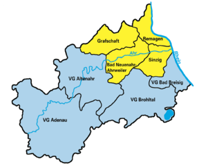
| current | 16:09, 30 January 2007 | | 1,500 × 1,264 (57 KB) | Sozi (talk | contribs) | {{Information |Description=Karte des Landkreises Ahrweiler, Rheinland-Pfalz, Deutschland |Source=Own work |Date=30-01-2007 |Author=~~~ |Permission=PD-own work |other_versions= }} |
You cannot overwrite this file.
File usage on Commons
The following page uses this file:
File usage on other wikis
The following other wikis use this file:
- Usage on de.wikipedia.org
- Usage on pl.wikipedia.org