File:Krammersluizen 03.jpg

Original file (2,760 × 1,410 pixels, file size: 1.82 MB, MIME type: image/jpeg)
Captions
Captions
Summary[edit]
| Description |
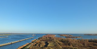
Nederlands: Het Krammersluizencomplex is gelegen in de Philipsdam en verzorgt de scheepvaartverbinding tussen de Oosterschelde en het Volkerak-Zoommeer. Het complex bestaat uit twee duwvaartsluizen met een lengte van elk 280 m en een breedte van 24 m. De duwvaartsluizen bieden ruimte voor binnenvaartschepen met vier duwbakken.
Tevens zijn er twee jachtsluizen met een lengte van elk 75 m en een breedte van 9 m. Gezien de drukte op het vaarwater ter plaatse heeft men de beroeps- en de recreatievaart, ook in de aanlooproutes naar de sluizen gescheiden gehouden.
English: The Karmmer locks complex in the Philips dam, which is the shipping connection between the Oosterschelde and Volkerak-Zoommeer. The locks are technically sophisticated because they must avoid the exchange between the freshwater Volkerak and the brackish water of the Oosterschelde. The locks are designed so that there is no influx of saltwater that enters the Volkerak and only a little fresh water in the Oosterschelde. |
| Date | |
| Source | Own work |
| Author | Ad Meskens |
You are free to use this picture for any purpose as long as you credit its author, Ad Meskens.
Example: © Ad Meskens / Wikimedia Commons
![]() If you use this work outside of the Wikimedia projects, a message or a copy is very much appreciated.
If you use this work outside of the Wikimedia projects, a message or a copy is very much appreciated.
 This image is not in the public domain. A statement such as "From Wikimedia Commons" or similar is not by itself sufficient. If you do not provide clear attribution to the author you didn't comply with the terms of the file's license and may not use this file. If you are unable or unwilling to provide attribution you should contact Ad Meskens to negotiate a different license.
This file has been released under a license which is incompatible with Facebook's licensing terms. It is not permitted to upload this file to Facebook.
![]()
| Camera location | | View this and other nearby images on: OpenStreetMap |
|---|
Licensing[edit]
- You are free:
- to share – to copy, distribute and transmit the work
- to remix – to adapt the work
- Under the following conditions:
- attribution – You must give appropriate credit, provide a link to the license, and indicate if changes were made. You may do so in any reasonable manner, but not in any way that suggests the licensor endorses you or your use.
- share alike – If you remix, transform, or build upon the material, you must distribute your contributions under the same or compatible license as the original.
File history
Click on a date/time to view the file as it appeared at that time.
| Date/Time | Thumbnail | Dimensions | User | Comment | |
|---|---|---|---|---|---|
| current | 17:47, 15 September 2016 | | 2,760 × 1,410 (1.82 MB) | Ad Meskens (talk | contribs) | User created page with UploadWizard |
You cannot overwrite this file.
File usage on Commons
The following 2 pages use this file: