File:Kort over Rygård herregård i Svendborg amt. Baseret på kort fra 1809.png
Jump to navigation
Jump to search

Size of this preview: 447 × 599 pixels. Other resolutions: 179 × 240 pixels | 358 × 480 pixels | 573 × 768 pixels | 764 × 1,024 pixels | 1,932 × 2,590 pixels.
Original file (1,932 × 2,590 pixels, file size: 1.78 MB, MIME type: image/png)
Captions
Captions
Add a one-line explanation of what this file represents
Summary[edit]
| Description |
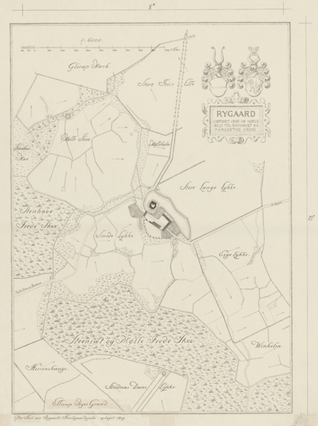
English: Map of the manor of Rygård in Svendborg amt, measured to scale 1:6000, based on a map from 1809. Probably drawn by Valdemar Koch. Koch made other drawings of Rygård in 1883 and signed most of them. Dansk: Kort over Rygård herregård i Svendborg amt, opmålt i skala 1:6000, baseret på kort fra 1809. Formentlig udført af Valdemar Koch. Koch udførte adskillige tegninger af Rygård i 1883 og signerede de fleste. |
|||||
| Date | circa 1883 | |||||
| Source | kunstbib.dk | |||||
| Author | Otto Valdemar Koch (1852-1902) | |||||
| Permission (Reusing this file) |
|
|||||
| Other versions |
|
|||||

File history
Click on a date/time to view the file as it appeared at that time.
| Date/Time | Thumbnail | Dimensions | User | Comment | |
|---|---|---|---|---|---|
| current | 12:13, 2 March 2020 | | 1,932 × 2,590 (1.78 MB) | Rsteen (talk | contribs) | {{Information |description={{en|1= Map of the manor of Rygård in Svendborg amt, measured to scale 1:6000, based on a map from 1809. Probably drawn by Valdemar Koch. Koch made other drawings of Rygård in 1883 and signed most of them. }} {{da|1=Kort over Rygård herregård i Svendborg amt, opmålt i skala 1:6000, baseret på kort fra 1809. Formentlig udført af Valdemar Koch. Koch udførte adskillige tegninger af Rygård i 1883 og signerede de fleste.}} |date={{other date|circa|1883}} |source= [http:/... |
You cannot overwrite this file.
File usage on Commons
The following page uses this file: