File:Korkedalen from Hesten in Senja, Troms og Finnmark, Norway, 2022 August.jpg
Jump to navigation
Jump to search

Size of this preview: 800 × 357 pixels. Other resolutions: 320 × 143 pixels | 640 × 285 pixels | 1,024 × 456 pixels | 1,280 × 570 pixels | 2,560 × 1,141 pixels | 6,440 × 2,870 pixels.
Original file (6,440 × 2,870 pixels, file size: 16.86 MB, MIME type: image/jpeg)
Captions
Captions
Add a one-line explanation of what this file represents
Summary[edit]
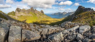
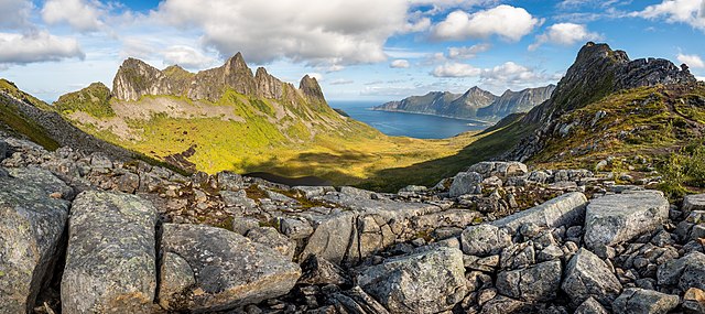
| Description | The mountains Floget, Inste Kongen, Svartvasstinden and Stavelitippen and the valley Korkedalen as seen from the hillside of Hesten in Senja, Troms og Finnmark, Norway in 2022 August. The lake below is Korkedalsvatnet and the outlet river is Korkedalselva. The fjord on the right is Øyfjorden. |
| Date | |
| Source | Own work |
| Author | Ximonic (Simo Räsänen) |
| Camera location | | View this and other nearby images on: OpenStreetMap |
|---|
This file was uploaded with VicuñaUploader.
Licensing[edit]
This file is licensed under the Creative Commons Attribution-Share Alike 4.0 International license.
Attribution: Simo Räsänen
- You are free:
- to share – to copy, distribute and transmit the work
- to remix – to adapt the work
- Under the following conditions:
- attribution – You must give appropriate credit, provide a link to the license, and indicate if changes were made. You may do so in any reasonable manner, but not in any way that suggests the licensor endorses you or your use.
- share alike – If you remix, transform, or build upon the material, you must distribute your contributions under the same or compatible license as the original.
| Annotations | This image is annotated: View the annotations at Commons |
This image has been assessed using the Quality image guidelines and is considered a Quality image.
|
File history
Click on a date/time to view the file as it appeared at that time.
| Date/Time | Thumbnail | Dimensions | User | Comment | |
|---|---|---|---|---|---|
| current | 18:50, 19 April 2023 | | 6,440 × 2,870 (16.86 MB) | Ximonic (talk | contribs) | VicuñaUploader 1.3.3a |
You cannot overwrite this file.
File usage on Commons
The following 4 pages use this file: