File:Kirgisen-Reich (840-924).PNG
Jump to navigation
Jump to search
Size of this preview: 800 × 499 pixels. Other resolutions: 320 × 199 pixels | 640 × 399 pixels | 1,024 × 638 pixels | 1,253 × 781 pixels.
Original file (1,253 × 781 pixels, file size: 1.42 MB, MIME type: image/png)
Captions
Captions
Add a one-line explanation of what this file represents
Summary[edit]
.PNG&action=edit§ion=1)
| Description |
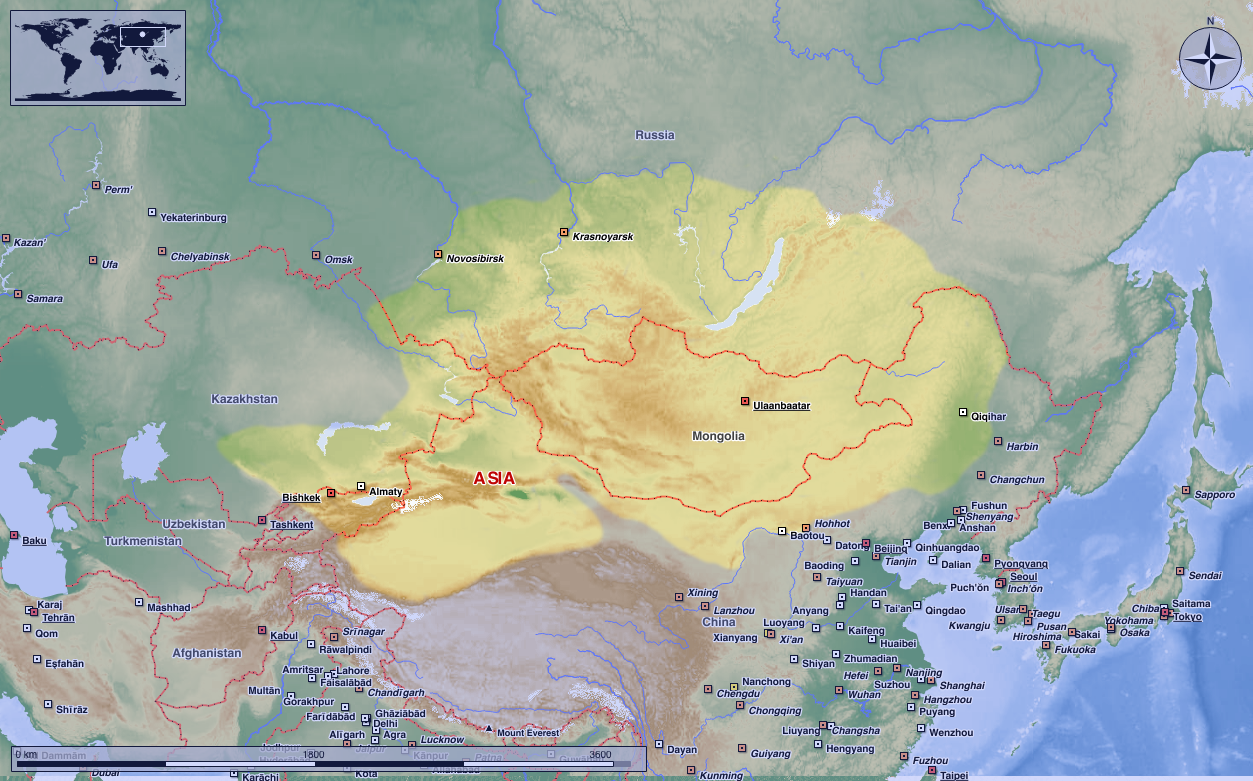
Deutsch: Das Kirgisen-Reich in seiner größten Ausdehung.
(Original text: Darstellungskarte zeigt das Kirgisen-Reich, das 840 das stammverwandte Reich der Uiguren zerschlug und dessen Erbe antrat.) 中文:叶尼塞吉尔吉斯的活动范围,吉尔吉斯人并没有在蒙古高原建立稳固的政权。
English: The map shows the Kyrgyz empire, which destroyed the related empire of the Uyghurs in 840 and inherited it. Kyrgyz Khaganate activity range, Kyrgyz people did not establish a stable political power in the Mongolian plateau.
|
| Date | 17 August 2004 (original upload date) |
| Source | Transferred from de.wikipedia to Commons. |
| Author | Postmann Michael |
| Permission (Reusing this file) |
Public Domain |
Licensing[edit]
.PNG&action=edit§ion=2)
| I, the copyright holder of this work, release this work into the public domain. This applies worldwide. In some countries this may not be legally possible; if so: I grant anyone the right to use this work for any purpose, without any conditions, unless such conditions are required by law. |
Original upload log[edit]
.PNG&action=edit§ion=3)
The original description page was here. All following user names refer to de.wikipedia.
- 2004-08-17 00:57 Postmann Michael 752×591× (37783 bytes) Das Kirgisen-Reich in seiner größten Ausdehung.
File history
Click on a date/time to view the file as it appeared at that time.
| Date/Time | Thumbnail | Dimensions | User | Comment | |
|---|---|---|---|---|---|
| current | 00:44, 21 August 2023 | | 1,253 × 781 (1.42 MB) | HapHaxion (talk | contribs) | Reverted to version as of 17:01, 15 April 2021 (UTC) |
| 23:18, 8 May 2023 |  | 1,048 × 614 (757 KB) | JJUPLOADS22 (talk | contribs) | Reverted to version as of 20:27, 14 April 2021 (UTC) | |
| 17:01, 15 April 2021 |  | 1,253 × 781 (1.42 MB) | MicBy67 (talk | contribs) | Reverted to version as of 14:30, 22 August 2020 (UTC). No improvement. | |
| 20:27, 14 April 2021 |  | 1,048 × 614 (757 KB) | Бмхүн (talk | contribs) | Adjust resolution | |
| 14:30, 22 August 2020 |  | 1,253 × 781 (1.42 MB) | MicBy67 (talk | contribs) | Reverted to version as of 14:05, 22 August 2020 (UTC) | |
| 14:30, 22 August 2020 |  | 752 × 591 (37 KB) | MicBy67 (talk | contribs) | Reverted to version as of 17:09, 10 May 2009 (UTC) | |
| 14:05, 22 August 2020 |  | 1,253 × 781 (1.42 MB) | MicBy67 (talk | contribs) | Revision of the existing file. Topography, cities, etc. according to Marble (public domain) | |
| 17:09, 10 May 2009 |  | 752 × 591 (37 KB) | Nachcommonsverschieber (talk | contribs) | {{Information |Description={{de|Das Kirgisen-Reich in seiner größten Ausdehung. ----<br/> (Original text : ''Darstellungskarte zeigt das Kirgisen-Reich, das 840 das stammverwandte Reich der Uiguren zerschlug und dessen Erbe antrat.'') * erstellt am: 17. |
You cannot overwrite this file.
File usage on Commons
The following 3 pages use this file:
File usage on other wikis
The following other wikis use this file:
- Usage on ar.wikipedia.org
- Usage on az.wikipedia.org
- Usage on bn.wikipedia.org
- Usage on de.wikipedia.org
- Usage on en.wikipedia.org
- Usage on fa.wikipedia.org
- Usage on fr.wikipedia.org
- Usage on id.wikibooks.org
- Usage on kk.wikipedia.org
- Usage on pt.wikipedia.org
- Usage on ru.wikipedia.org
- Usage on ta.wikipedia.org
- Usage on tr.wikipedia.org
- Usage on uz.wikipedia.org
- Usage on www.wikidata.org
.PNG&oldid=794766475)