File:Khazar map1.PNG
Jump to navigation
Jump to search

Size of this preview: 800 × 504 pixels. Other resolutions: 320 × 202 pixels | 640 × 403 pixels | 939 × 592 pixels.
Original file (939 × 592 pixels, file size: 548 KB, MIME type: image/png)
Captions
Captions
Add a one-line explanation of what this file represents
Summary[edit]
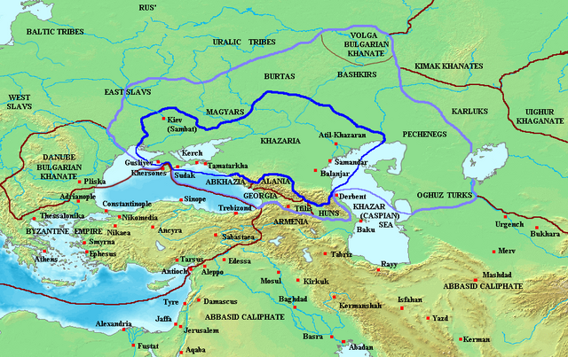
Map of the Khazar Khaganate and surrounding states, c. 820 CE. Area of direct Khazar control shown in dark blue, sphere of influence in purple. Other boundaries shown in dark red.
Made by User:Briangotts
Licensing[edit]
| This file is licensed under the Creative Commons Attribution-Share Alike 3.0 Unported license. Subject to disclaimers. | ||
| ||
| This licensing tag was added to this file as part of the GFDL licensing update. |

|
Permission is granted to copy, distribute and/or modify this document under the terms of the GNU Free Documentation License, Version 1.2 or any later version published by the Free Software Foundation; with no Invariant Sections, no Front-Cover Texts, and no Back-Cover Texts. A copy of the license is included in the section entitled GNU Free Documentation License. Subject to disclaimers. |
File history
Click on a date/time to view the file as it appeared at that time.
| Date/Time | Thumbnail | Dimensions | User | Comment | |
|---|---|---|---|---|---|
| current | 07:29, 26 June 2023 | | 939 × 592 (548 KB) | Johannnes89 (talk | contribs) | Reverted to version as of 18:29, 20 May 2016 (UTC) crosswiki image spam, often containing historical inaccuracies |
| 23:56, 25 June 2023 |  | 939 × 592 (657 KB) | Valdazleifr (talk | contribs) | Fixed a minor toponymycal error | |
| 18:29, 20 May 2016 |  | 939 × 592 (548 KB) | Julieta39 (talk | contribs) | Lakes, rivers, shorelines of the time, cosmetic. | |
| 15:20, 27 October 2006 |  | 939 × 592 (336 KB) | Frode Inge Helland (talk | contribs) | == Summary == Map of the Khazar Khaganate and surrounding states, c. 820 CE. Area of direct Khazar control shown in dark blue, sphere of influence in purple. Other boundaries shown in dark red. Category:Historical maps by User:Briangotts == L | |
| 15:17, 27 October 2006 |  | 939 × 592 (336 KB) | Frode Inge Helland (talk | contribs) | == Summary == Map of the Khazar Khaganate and surrounding states, c. 820 CE. Area of direct Khazar control shown in dark blue, sphere of influence in purple. Other boundaries shown in dark red. Category:Historical maps by User:Briangotts == L |
You cannot overwrite this file.
File usage on Commons
The following page uses this file:
File usage on other wikis
The following other wikis use this file:
- Usage on be-tarask.wikipedia.org
- Usage on da.wikipedia.org
- Usage on el.wikipedia.org
- Usage on en.wikipedia.org
- Usage on fr.wikipedia.org
- Usage on hu.wikipedia.org
- Usage on it.wikipedia.org
- Usage on ja.wikipedia.org
- Usage on mk.wikipedia.org
- Usage on no.wikipedia.org
- Usage on pnb.wikipedia.org
- Usage on sl.wikipedia.org
- Usage on tt.wikipedia.org
- Usage on uk.wikipedia.org
- Usage on zh.wikipedia.org