File:Kessel von Cholm - Karte.png
Jump to navigation
Jump to search
Size of this preview: 432 × 600 pixels. Other resolutions: 173 × 240 pixels | 346 × 480 pixels | 923 × 1,281 pixels.
Original file (923 × 1,281 pixels, file size: 512 KB, MIME type: image/png)
Captions
Captions
Add a one-line explanation of what this file represents
Summary[edit]
| Description |
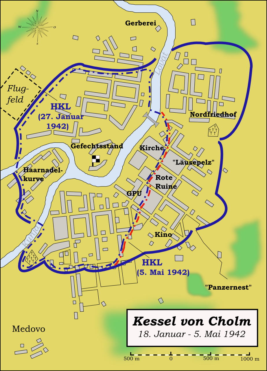
English: Map (in German language) showing the pocket of Kholm (January - May 1942) during the German-Soviet War 1941-1945. Hrvatski: Okruženje kod Holma - karta. Русский: Холмский котел - карта. Deutsch: Kessel von Cholm - Karte. |
| Date | |
| Source | Own work by uploader, based on different maps as sources, mainly from Otto Karsten: Cholm, 1944 (= Schriftenreihe zur Truppenbetreuung, Bd.55) and Richard Muck: Kampfgruppe Scherer - 105 Tage eingeschlossen, Gerhard Stalling Verlag, Oldenburg 1943. |
| Author | Memnon335bc |
Licensing[edit]
I, the copyright holder of this work, hereby publish it under the following licenses:
This file is licensed under the Creative Commons Attribution-Share Alike 3.0 Unported license.
- You are free:
- to share – to copy, distribute and transmit the work
- to remix – to adapt the work
- Under the following conditions:
- attribution – You must give appropriate credit, provide a link to the license, and indicate if changes were made. You may do so in any reasonable manner, but not in any way that suggests the licensor endorses you or your use.
- share alike – If you remix, transform, or build upon the material, you must distribute your contributions under the same or compatible license as the original.

|
Permission is granted to copy, distribute and/or modify this document under the terms of the GNU Free Documentation License, Version 1.2 or any later version published by the Free Software Foundation; with no Invariant Sections, no Front-Cover Texts, and no Back-Cover Texts. A copy of the license is included in the section entitled GNU Free Documentation License. |
You may select the license of your choice.
File history
Click on a date/time to view the file as it appeared at that time.
| Date/Time | Thumbnail | Dimensions | User | Comment | |
|---|---|---|---|---|---|
| current | 01:25, 12 August 2009 | | 923 × 1,281 (512 KB) | Memnon335bc (talk | contribs) | Maßstab ergänzt |
| 00:17, 6 February 2009 |  | 923 × 1,281 (506 KB) | Memnon335bc (talk | contribs) | == Summary == {{Information |Description={{en|1=Map (in German language) showing the pocket of Kholm (Januar - May 1942) during the German-Soviet War 1941-1945.}} |Source=Own work by uploader, based on different maps as sources, mainly from Otto Karsten: | |
| 19:04, 4 January 2009 |  | 923 × 1,281 (508 KB) | Memnon335bc (talk | contribs) | {{Information |Description={{en|1=Map (in German language) showing the pocket of Kholm (Januar - May 1942) during the German-Soviet War 1941-1945.}} |Source=Own work by uploader, based on different maps as sources, mainly from Otto Karsten: ''Cholm, 1944' |
You cannot overwrite this file.
File usage on Commons
The following page uses this file:
File usage on other wikis
The following other wikis use this file:
- Usage on ar.wikipedia.org
- Usage on de.wikipedia.org
- Usage on en.wikipedia.org
- Usage on es.wikipedia.org
- Usage on fi.wikipedia.org
- Usage on fr.wikipedia.org
- Usage on ja.wikipedia.org
- Usage on pl.wikipedia.org
- Usage on th.wikipedia.org
- Usage on uk.wikipedia.org