File:Kentucky River Lock Number Seven Upper End of Land Wall - DPLA - 3ada17ff01e5c2bf815c90f512715ea3.jpg
Jump to navigation
Jump to search

Size of this preview: 725 × 600 pixels. Other resolutions: 290 × 240 pixels | 581 × 480 pixels | 929 × 768 pixels | 1,238 × 1,024 pixels | 2,477 × 2,048 pixels | 3,150 × 2,605 pixels.
Original file (3,150 × 2,605 pixels, file size: 1.52 MB, MIME type: image/jpeg)
Captions
Captions
Add a one-line explanation of what this file represents
Summary[edit]
| Kentucky River Lock Number Seven Upper End of Land Wall
( |
|||||||||||||||||||||
|---|---|---|---|---|---|---|---|---|---|---|---|---|---|---|---|---|---|---|---|---|---|
| Creator | Department of Defense. Department of the Army. Ohio River Division. Office of the Chief of Engineers. Louisville District. (9/18/1947 - 6/14/1979) | ||||||||||||||||||||
| Title |
Kentucky River Lock Number Seven Upper End of Land Wall |
||||||||||||||||||||
| Description |
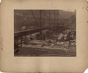
Original caption: Improving Kentucky River. Lock No. 7. Upper End of Land Wall. September 10, 1896. No. 50. |
||||||||||||||||||||
| Date | 10 September 1896 | ||||||||||||||||||||
| Collection |
|
||||||||||||||||||||
| Source/Photographer |
|
||||||||||||||||||||
| Permission (Reusing this file) |
|
||||||||||||||||||||
| Standardized rights statement |
|
||||||||||||||||||||


File history
Click on a date/time to view the file as it appeared at that time.
| Date/Time | Thumbnail | Dimensions | User | Comment | |
|---|---|---|---|---|---|
| current | 03:21, 25 November 2020 | | 3,150 × 2,605 (1.52 MB) | DPLA bot (talk | contribs) | Uploading DPLA ID 3ada17ff01e5c2bf815c90f512715ea3 |
You cannot overwrite this file.
File usage on Commons
The following page uses this file: