File:Kent Roosevelt district.png
Jump to navigation
Jump to search

Size of this preview: 578 × 600 pixels. Other resolutions: 231 × 240 pixels | 463 × 480 pixels | 740 × 768 pixels | 987 × 1,024 pixels | 1,800 × 1,868 pixels.
Original file (1,800 × 1,868 pixels, file size: 1.22 MB, MIME type: image/png)
Captions
Captions
Add a one-line explanation of what this file represents
| Description |
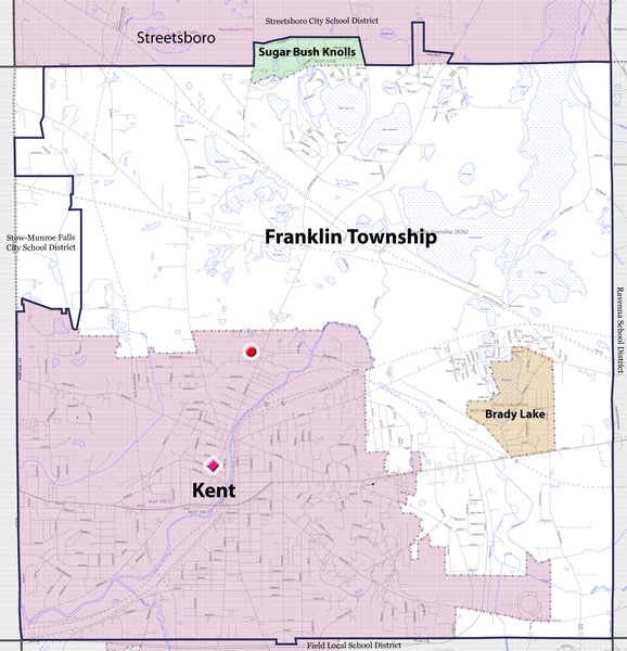
English: Map showing location of Theodore Roosevelt High School and the Central School Annex within the boundaries of the Kent City School District in Kent, Ohio, USA. The district includes most of Kent and Franklin Township and all of the villages of Brady Lake and Sugar Bush Knolls and a very small portion of Streetsboro.
School district boundaries are superimposed over the U.S. Census Bureau map. The boundaries of the Kent City School district are the dark blue solid lines; boundaries of neighboring school districts are dark gray solid lines. Theodore Roosevelt High School is indicated by the solid red circle just to the left of the center of the image with the Central School Annex represented by the pink diamond. The various townships and municipalities and their respective boundaries are represented by the shaded areas and dotted lines. |
|||
| Date | ||||
| Source |
|
|||
| Author | JonRidinger | |||
| Permission (Reusing this file) |
I, the copyright holder of this work, hereby publish it under the following licenses:
This file is licensed under the Creative Commons Attribution 3.0 Unported license.
You may select the license of your choice. |

File history
Click on a date/time to view the file as it appeared at that time.
| Date/Time | Thumbnail | Dimensions | User | Comment | |
|---|---|---|---|---|---|
| current | 21:01, 10 October 2012 | | 1,800 × 1,868 (1.22 MB) | JonRidinger (talk | contribs) | corrected boundaries |
| 05:18, 19 February 2011 |  | 1,800 × 1,868 (1.22 MB) | JonRidinger (talk | contribs) | slight change in size of shapes | |
| 05:16, 19 February 2011 |  | 1,800 × 1,868 (1.22 MB) | JonRidinger (talk | contribs) | Changed shapes and made them slightly easier to see | |
| 04:07, 9 November 2010 |  | 1,800 × 1,868 (1.21 MB) | JonRidinger (talk | contribs) | Boundary corrections | |
| 05:02, 28 October 2010 |  | 1,800 × 1,868 (1.21 MB) | JonRidinger (talk | contribs) | Added location of Central School annex | |
| 04:36, 28 October 2010 |  | 1,800 × 1,868 (1.21 MB) | JonRidinger (talk | contribs) | {{Information |Description={{en|1=Map showing location Theodore Roosevelt High School within the boundaries of the Kent City School District in Kent, Ohio, USA. The dis |
You cannot overwrite this file.
File usage on Commons
There are no pages that use this file.
File usage on other wikis
The following other wikis use this file:
- Usage on en.wikipedia.org