File:Kebira Crater.jpg
Jump to navigation
Jump to search

Size of this preview: 566 × 599 pixels. Other resolutions: 227 × 240 pixels | 453 × 480 pixels | 725 × 768 pixels | 1,168 × 1,237 pixels.
Original file (1,168 × 1,237 pixels, file size: 612 KB, MIME type: image/jpeg)
Captions
Captions
Add a one-line explanation of what this file represents
Summary[edit]
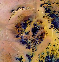
English: Landsat color composite image of the Kebira Crater in Egypt's Western Desert. The outer rim is 31 km in diameter, as indicated by the dashed circular curve superimposed on the image.
Courtesy of Boston University Center for Remote Sensing
![[2]](ftp://crsftp.bu.edu/pub/crs/kebira/bu_web_color.jpg)
Deutsch: Landsat Farbkompositbild des Kebira-Kraters in der Westlichen Wüste Ägyptens. Der äußere Rand hat 31 km Durchmesser, angedeutet durch die kreisförmige gestrichelte Kurve.
Licensing[edit]
| This file is in the public domain in the United States because it was solely created by NASA. NASA copyright policy states that "NASA material is not protected by copyright unless noted". (See Template:PD-USGov, NASA copyright policy page or JPL Image Use Policy.) | ||
 |
Warnings:
|
File history
Click on a date/time to view the file as it appeared at that time.
| Date/Time | Thumbnail | Dimensions | User | Comment | |
|---|---|---|---|---|---|
| current | 19:53, 4 March 2006 | | 1,168 × 1,237 (612 KB) | Pmsyyz (talk | contribs) | uploaded wrong copy |
| 19:51, 4 March 2006 |  | 5,950 × 7,700 (2.56 MB) | Pmsyyz (talk | contribs) | w:Kebira Crater, Western Desert, Egypt |
You cannot overwrite this file.
File usage on Commons
The following 2 pages use this file:
File usage on other wikis
The following other wikis use this file:
- Usage on ar.wikipedia.org
- Usage on arz.wikipedia.org
- Usage on cs.wikipedia.org
- Usage on de.wikipedia.org
- Usage on en.wikipedia.org
- Usage on es.wikipedia.org
- Usage on fr.wikipedia.org
- Usage on he.wikipedia.org
- Usage on it.wikipedia.org
- Usage on it.wikivoyage.org
- Usage on nn.wikipedia.org
- Usage on pl.wikipedia.org
- Usage on ru.wikipedia.org
- Usage on sk.wikipedia.org
- Usage on sv.wikipedia.org
- Usage on www.wikidata.org