File:Kaukasian geopoliittinen kartta.svg
Jump to navigation
Jump to search

Size of this PNG preview of this SVG file: 632 × 599 pixels. Other resolutions: 253 × 240 pixels | 506 × 480 pixels | 810 × 768 pixels | 1,080 × 1,024 pixels | 2,159 × 2,048 pixels | 972 × 922 pixels.
Original file (SVG file, nominally 972 × 922 pixels, file size: 383 KB)
Captions
Captions
Add a one-line explanation of what this file represents
Summary[edit]
| Description |
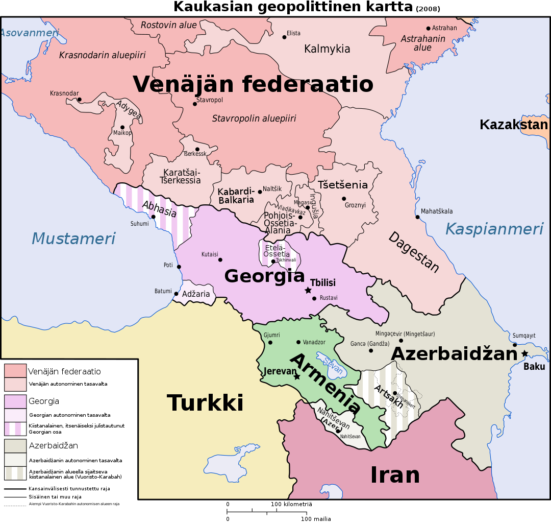
Suomi: Kaukasian geopoliittinen kartta (2008). Vapaasti käännetty ja hieman korjailtu versio Wikimedia Commonsin samanaiheisesta englanninkielisestä svg-kartasta (File:Caucasus-political_en.svg). English: Geopolitical map of Caucasus area (2008) in Finnish. Slightly updated version, based on this svg-map (File:Caucasus-political_en.svg) in English. |
| Date | |
| Source | Own work |
| Author | Paju |
| Other versions |
[]
|


.png)


This W3C-unspecified vector image was created with Inkscape .
Licensing[edit]
I, the copyright holder of this work, hereby publish it under the following license:
This file is licensed under the Creative Commons Attribution-Share Alike 4.0 International license.
- You are free:
- to share – to copy, distribute and transmit the work
- to remix – to adapt the work
- Under the following conditions:
- attribution – You must give appropriate credit, provide a link to the license, and indicate if changes were made. You may do so in any reasonable manner, but not in any way that suggests the licensor endorses you or your use.
- share alike – If you remix, transform, or build upon the material, you must distribute your contributions under the same or compatible license as the original.
File history
Click on a date/time to view the file as it appeared at that time.
| Date/Time | Thumbnail | Dimensions | User | Comment | |
|---|---|---|---|---|---|
| current | 22:54, 20 January 2020 | | 972 × 922 (383 KB) | Takhirgeran Umar (talk | contribs) | clarification |
| 05:01, 27 April 2018 |  | 972 × 922 (385 KB) | Kentronhayastan (talk | contribs) | Updated "Nagorno-Karabakh" to "Artsakh," the new official name of the self-proclaimed republic. | |
| 04:15, 14 January 2015 |  | 972 × 922 (385 KB) | Paju~commonswiki (talk | contribs) | Relocated text "Azerbaidžan" to avoid collision with city symbol for "Baku". | |
| 04:08, 14 January 2015 |  | 972 × 922 (385 KB) | Paju~commonswiki (talk | contribs) | 1. One translation typo/error was corrected (Suhumi, not Sukhumi in Finnish) 2. Added several cities with +100 000 persons in Armenia, Azerbaidjan and Georgia. Earlier, only in Georgia most of such larger cities were shown. In Russia only region (krai,... | |
| 02:14, 14 January 2015 |  | 972 × 922 (378 KB) | Paju~commonswiki (talk | contribs) | User created page with UploadWizard |
You cannot overwrite this file.
File usage on Commons
The following 20 pages use this file:
- File:Caucasus-political-fr.svg
- File:Caucasus-political-krc.svg
- File:Caucasus-political-ru.svg
- File:Caucasus-political-tr.svg
- File:Caucasus-political (hy).png
- File:Caucasus-political Fa.svg
- File:Caucasus-political ca.svg
- File:Caucasus-political cs.svg
- File:Caucasus-political de.svg
- File:Caucasus-political en.svg
- File:Caucasus-political es.svg
- File:Caucasus-political ja.svg
- File:Caucasus-political mk.svg
- File:Caucasus-political mzn.svg
- File:Caucasus-political nl.svg
- File:Caucasus-political pl.svg
- File:Caucasus-political pt.svg
- File:Caucasus-political vi.svg
- File:Kaukasian geopoliittinen kartta.svg
- Template:Other versions/Caucasus-political
File usage on other wikis
The following other wikis use this file:
- Usage on fi.wikipedia.org