File:Kastelle Nordbritannien.png
Jump to navigation
Jump to search
Size of this preview: 800 × 425 pixels. Other resolutions: 320 × 170 pixels | 640 × 340 pixels | 1,024 × 544 pixels | 1,280 × 680 pixels | 2,214 × 1,176 pixels.
Original file (2,214 × 1,176 pixels, file size: 941 KB, MIME type: image/png)
Captions
Captions
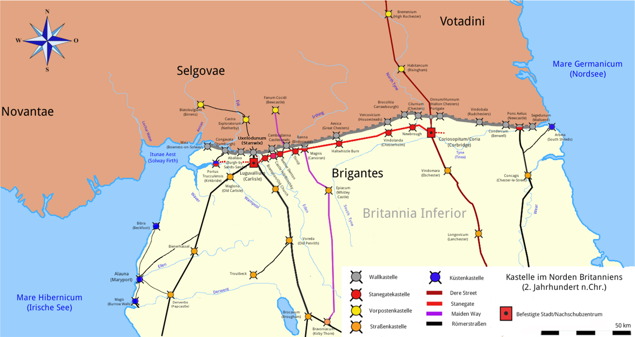
Map of Hadrian's wall's roman camp
Summary[edit]
| Description |
Deutsch: Lageskizze der Kastelle am Stanegate und Hadrianswall, inkl. Küstenschutz Cumbria und Vorposten in Caledonia, 2. Jahrhundert n. Chr. |
| Date | |
| Source | Own work |
| Author | Veleius |
Vorlage: Adrian Goldsworthy: Die Kriege der Römer. Brandenburgsches Verlagshaus, 2001, Plan S. 152.
Licensing[edit]
I, the copyright holder of this work, hereby publish it under the following license:
| This file is made available under the Creative Commons CC0 1.0 Universal Public Domain Dedication. | |
| The person who associated a work with this deed has dedicated the work to the public domain by waiving all of their rights to the work worldwide under copyright law, including all related and neighboring rights, to the extent allowed by law. You can copy, modify, distribute and perform the work, even for commercial purposes, all without asking permission.
|
File history
Click on a date/time to view the file as it appeared at that time.
| Date/Time | Thumbnail | Dimensions | User | Comment | |
|---|---|---|---|---|---|
| current | 08:53, 28 April 2020 | | 2,214 × 1,176 (941 KB) | Veleius (talk | contribs) | Kastellvignetten korr. |
| 14:30, 4 February 2018 |  | 2,214 × 1,176 (942 KB) | Veleius (talk | contribs) | kosmetische Änderungen | |
| 11:18, 10 December 2017 |  | 1,401 × 743 (276 KB) | Veleius (talk | contribs) | Kosmetische Änderungen | |
| 10:54, 9 December 2017 |  | 1,401 × 743 (283 KB) | Veleius (talk | contribs) | Ergänzt | |
| 23:50, 8 December 2017 |  | 1,401 × 743 (266 KB) | Veleius (talk | contribs) | Neu gestaltet und ergänzt. | |
| 22:21, 19 November 2017 |  | 2,013 × 1,197 (626 KB) | Veleius (talk | contribs) | {{Information |Description ={{de|1=Lageskizze der Kastelle am Stanegate und Hadrianswall, inkl. Küstenschutz Cumbria und Vorposten in Caledonia, 2. Jahrhundert n. Chr.}} |Source ={{own}} |Author =Veleius |Date... |
You cannot overwrite this file.
File usage on Commons
The following page uses this file:
File usage on other wikis
The following other wikis use this file:
- Usage on br.wikipedia.org
- Usage on de.wikipedia.org
- Hadrianswall
- Limes (Grenzwall)
- Vindolanda
- Stanegate
- Wikipedia:Redaktion Altertum/Römischer Limes
- Blatobulgium
- Arbeia
- Luguvalium
- Meilenkastelle und Wachtürme am Hadrianswall
- Segedunum
- Kastell Birdoswald
- Kastell Pons Aelius
- Condercum
- Vindobala
- Onnum
- Cilurnum
- Limes Britannicus
- Brocolitia
- Vercovicium
- Aesica
- Kastell Magnis
- Camboglanna
- Kastell Uxelodunum
- Aballava
- Congavata
- Kastell Maia
- Vorlage:Navigationsleiste Limes Britannien (Hadrianswall)
- Habitancum
- Kastell Bremenium
- Castra Exploratorum
- Fanum Cocidi
- Portus Trucculensis
- Coriosopitum
- Vindomora
- Kastelle von Newbrough
- Kleinkastell Haltwhistle Burn
- Kleinkastell Throp
- Kastell Nether Denton
- Kleinkastell Castle Hill
- Kastell Old Church
- Usage on fr.wikipedia.org
- Usage on it.wikipedia.org
- Usage on www.wikidata.org