File:Karte konstanz in deutschland.png
Jump to navigation
Jump to search
No higher resolution available.
Karte_konstanz_in_deutschland.png (188 × 235 pixels, file size: 5 KB, MIME type: image/png)
Captions
Captions
Add a one-line explanation of what this file represents
Summary[edit]
| Description |
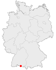
Deutsch: Karte von Deutschland mit den Grenzen der 16 Bundesländer
Quadratische Plattkarte, N-S-Streckung 150 %. Geographische Begrenzung der Karte:
English: Map of Germany with the borders of the 16 federal states
Equirectangular projection, N/S stretching 150 %. Geographic limits of the map:
|
||
| Date | |||
| Source | Own work | ||
| Author | NordNordWest | ||
| Permission (Reusing this file) |
This image was generated with OpenGeoDB. The information there is placed in the public domain, images generated from OpenGeoDB are derivative works without passing the threshold of creativity, they are therefore also public domain.
|
||
| Other versions |
|


|
This map has been made or improved in the German Kartenwerkstatt (Map Lab). You can propose maps to improve as well.
|
File history
Click on a date/time to view the file as it appeared at that time.
| Date/Time | Thumbnail | Dimensions | User | Comment | |
|---|---|---|---|---|---|
| current | 05:52, 23 December 2005 | | 188 × 235 (5 KB) | Roo72 (talk | contribs) | from de Wiki category:maps |
You cannot overwrite this file.
File usage on Commons
There are no pages that use this file.
File usage on other wikis
The following other wikis use this file:
- Usage on af.wikipedia.org
- Usage on ja.wikipedia.org
- Usage on pl.wikivoyage.org
- Usage on zh.wikipedia.org