File:Karte Weihnachtshochwasser 2023.png
Jump to navigation
Jump to search

Size of this preview: 480 × 600 pixels. Other resolutions: 192 × 240 pixels | 384 × 480 pixels | 614 × 768 pixels | 819 × 1,024 pixels | 1,639 × 2,048 pixels | 8,001 × 10,000 pixels.
Original file (8,001 × 10,000 pixels, file size: 8.49 MB, MIME type: image/png)
Captions
Captions
Add a one-line explanation of what this file represents
Summary[edit]
| Description |
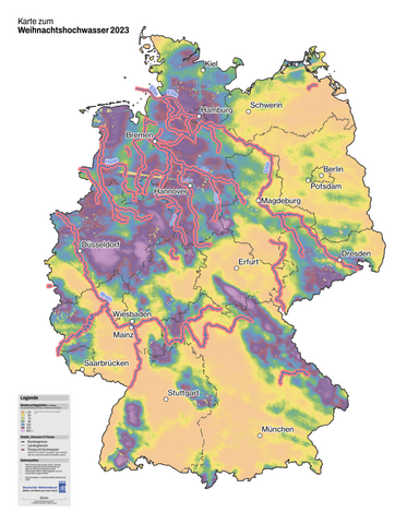
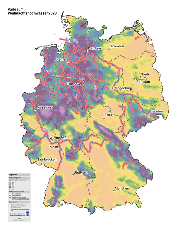
Deutsch: Die Karte zeigt die Niederschlagshöhe zwischen dem 22.12.2023 und dem 03.01.2024 sowie betroffene Hochwassergebiete (Auswahl) |
|||
| Date | ||||
| Source |
Own work, Datenquellen:
|
|||
| Author | Ovinator | |||
| Permission (Reusing this file) |
This file is licensed under the Creative Commons Attribution-Share Alike 4.0 International license.
Deutsch: Wichtiger Hinweise bzgl. OpenData-Portal des Deutschen Wetterdiensts gem. Verordnung zur Festlegung der Nutzungsbestimmungen für die Bereitstellung von Geodaten des Bundes vom 19. März 2013 (BGBl. I S. 547) (GEoNutzV). Die Rechstfolgen der GeoNutzV sind unklar, besonders bzgl. abgeleiteter Dateien, inbes. bei Einarbeitung anders lizenzierter Daten. Es dürfte daher ratsam sein, die DWD-Quellenangaben immer auch in allen abgeleiteten Werken anzugeben. English: Important note for all data attributed OpenData portal of Deutscher Wetterdienst according Verordnung zur Festlegung der Nutzungsbestimmungen für die Bereitstellung von Geodaten des Bundes vom 19. März 2013 (BGBl. I S. 547) (GEoNutzV). It's not clear what this act implies in terms of which licenses are applicable for derived works especially those where differently licensed data is incorporated. It may be best to keep the attribution to DWD-data in every file derived. |

|
This map has been made or improved in the German Kartenwerkstatt (Map Lab). You can propose maps to improve as well.
|

|
Diese Karte bedarf einer Aktualisierung oder enthält Fehler? Melde das gerne auf meiner Diskussionsseite!
Auch Verbesserungsvorschläge, die die Gestaltung der Karte (Typografie, Farbgebung, etc.) betreffen, sind gerne gesehen.
|
File history
Click on a date/time to view the file as it appeared at that time.
| Date/Time | Thumbnail | Dimensions | User | Comment | |
|---|---|---|---|---|---|
| current | 19:04, 9 January 2024 | | 8,001 × 10,000 (8.49 MB) | Ovinator (talk | contribs) | Legende größer, zuvor vertauschte Beschriftungen korrigiert |
| 12:42, 7 January 2024 |  | 8,001 × 10,000 (8.38 MB) | Ovinator (talk | contribs) | Mehr betroffene Flüsse eingezeichnet; Jahresangabe in Legende korrigiert | |
| 17:13, 6 January 2024 |  | 8,001 × 10,000 (8.32 MB) | Ovinator (talk | contribs) | == {{int:filedesc}} == {{Information |Description={{de|1=Die Karte zeigt die Niederschlagshöhe zwischen dem 22.12.2023 und dem 03.01.2024 sowie betroffene Hochwassergebiete (Auswahl)}} |Source={{own}}, Datenquellen: * [https://opendata.dwd.de OpenData-Portal des Deutschen Wetterdiensts]: [https://opendata.dwd.de/climate_environment/CDC/grids_germany/daily/radolan/ ''DWD Climate Data Center (CDC), Aktuelle stündlich gleitende RADOLAN-Raster der täglichen Niederschlagshöhe (binär)''] gem. [htt... |
You cannot overwrite this file.
File usage on Commons
There are no pages that use this file.
File usage on other wikis
The following other wikis use this file:
- Usage on de.wikipedia.org