File:Karte Verteilung der Reichsdörfer.png
Jump to navigation
Jump to search
Size of this preview: 800 × 490 pixels. Other resolutions: 320 × 196 pixels | 640 × 392 pixels | 1,024 × 627 pixels | 1,280 × 784 pixels | 2,853 × 1,747 pixels.
Original file (2,853 × 1,747 pixels, file size: 1.31 MB, MIME type: image/png)
Captions
Captions
Add a one-line explanation of what this file represents
Summary[edit]
| Description |
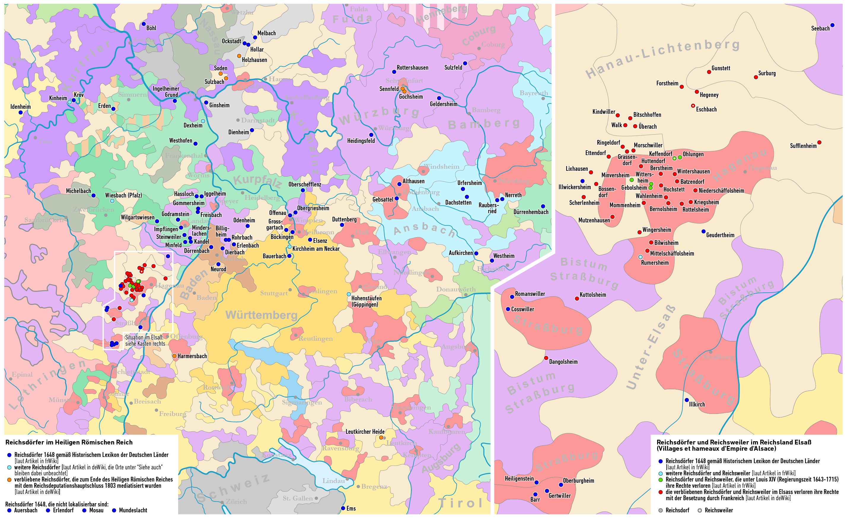
Deutsch: Karte: Verteilung der Reichsdörfer und Reichsweiler im Heiligen Römischen Reich
English: Map: Imperial Village distribution in the Holy Roman Empire
Français : Carte: Distribution des villages d'Empire dans le Saint Empire romain germanique |
| Date | see file history |
| Source | Own work using: Karte des Heiligen Römischen Reichs 1618 by Sir Iain |
| Author | Maximilian Dörrbecker (Chumwa) |
| Permission (Reusing this file) |
I, the copyright holder of this work, hereby publish it under the following license: This file is licensed under the Creative Commons Attribution-Share Alike 2.5 Generic license.
Sie dürfen das Bild zu den folgenden Bedingungen nutzen:
|
| Other versions |
|


_-_DE.svg)
File history
Click on a date/time to view the file as it appeared at that time.
| Date/Time | Thumbnail | Dimensions | User | Comment | |
|---|---|---|---|---|---|
| current | 08:00, 3 December 2017 | | 2,853 × 1,747 (1.31 MB) | Chumwa (talk | contribs) | |
| 21:34, 1 December 2017 |  | 2,853 × 1,747 (1.29 MB) | Chumwa (talk | contribs) | ||
| 06:28, 27 November 2017 |  | 1,337 × 1,615 (692 KB) | Chumwa (talk | contribs) | ||
| 06:23, 27 November 2017 |  | 1,337 × 1,615 (692 KB) | Chumwa (talk | contribs) | ||
| 22:59, 26 November 2017 |  | 1,337 × 1,615 (617 KB) | Chumwa (talk | contribs) | ||
| 22:43, 26 November 2017 |  | 1,337 × 1,615 (643 KB) | Chumwa (talk | contribs) | ||
| 21:32, 26 November 2017 |  | 1,337 × 1,615 (645 KB) | Chumwa (talk | contribs) | ||
| 21:20, 26 November 2017 |  | 1,337 × 1,615 (587 KB) | Chumwa (talk | contribs) | ||
| 21:06, 26 November 2017 |  | 1,337 × 1,615 (578 KB) | Chumwa (talk | contribs) | Neuer Hintergrund: HRR 1618 | |
| 09:20, 26 November 2017 |  | 806 × 785 (184 KB) | Chumwa (talk | contribs) | == {{int:filedesc}} == {{Information | Description = {{de|1=Karte: Verteilung der Reichsdörfer und Reichsweiler im Heiligen Römischen reich}} |Source = {{own using}} * Landkarte von Europa um 1714 |Date... |
You cannot overwrite this file.
File usage on Commons
The following 3 pages use this file:
File usage on other wikis
The following other wikis use this file:
- Usage on de.wikipedia.org
- Usage on it.wikipedia.org
- Usage on ru.wikipedia.org
- Usage on zh.wikipedia.org